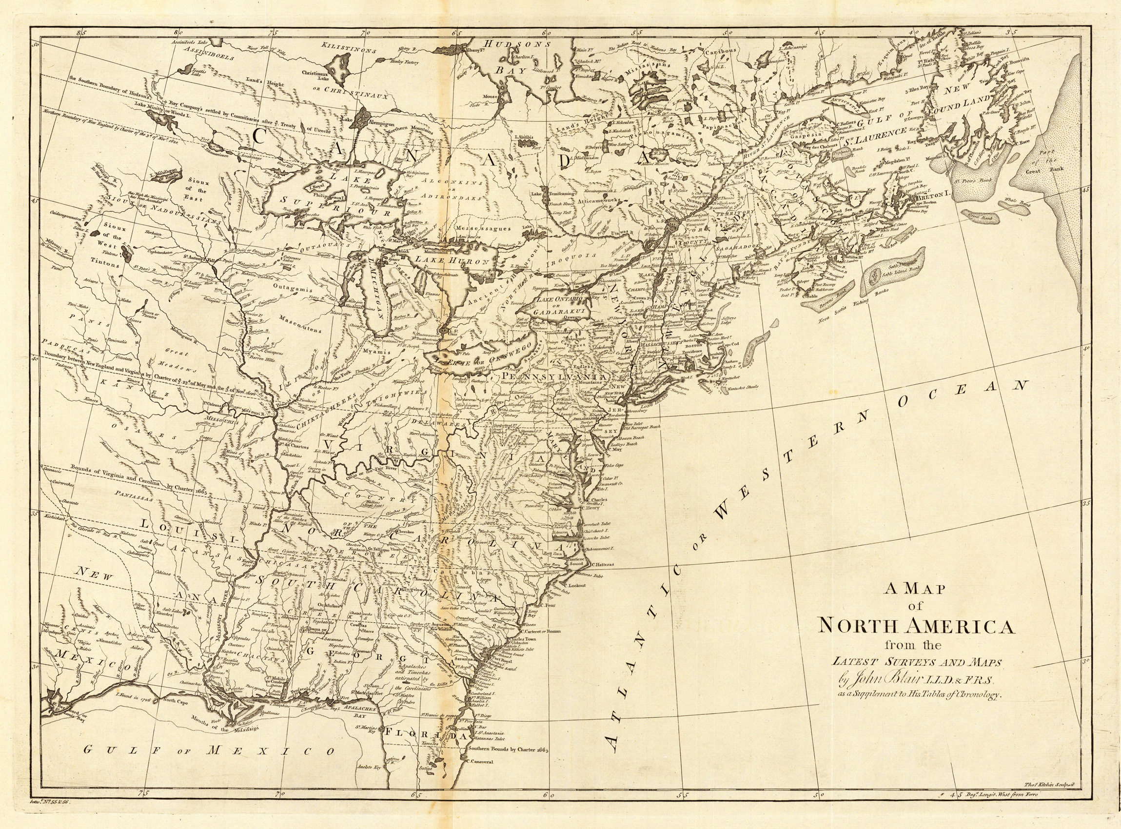
Copper-engraving, uncolored, engraved by Thomas Kitchin. Important map, showing the eastern North America, however excluding Florida and the northern Canada. Several Indian tribes and related informations are designated on the map. Four false islands are shown in lake Superior. The map is showing mainly the British North America east of the Mississippi. The southern colonies are extending as far as the Mississippi, their borders are stretching into the plains. The map is providing rich detailled information, the rivers are well designated, many names of towns are cities are shown on the map.
Original antique hand colored lithograph. This climatotlogical map is from "The National Atlas, containing Elaborate Topographical Maps of the United States and the Dominion of Canada, with Plans of Cities and General Maps of the World".
Copper engraving, hand colored in outline and wash. Engraved by Ales after the map of the United States by John Melish, published in Jean Alexandre C. Buchon's ,Atlas Geographique des deux Ameriques' in Paris 1825. This edition by Jean Alexandre Buchon was published three years after Carey & Lea s important American Atlas. Jean Buchon issued his revised French edition of the atlas 1825 in Paris. Fine engraved map showing the United States in 1825. Detailed map showing the various states with its political borders in fine colors. This interesting map is showing the remainder of the Louisiana Territory: the Missouri Territory and the Arkansas Territory. The area of the great plains is named Grand Desert Americain , derived from Stephen H. Long s important expedition of 1819-20. With many engraved place names, rivers, mountains, etc. Further the map provides good information on the river system of the United States, names of Indian tribes are engraved, as well trails. With the neighboring Texas and New Mexico, also in the Northwest the map extends towards the Oregon Territory. General map of the US published in Jean Alexandre Buchon s atlas. The map is based on John Melish's map in 1823 of the United States.
Original hand colored lithograph. This beautifully colored antique map shows nine different geological classifications, each identified in a key at lower left. The title is engraved above the map. Dr. Charles H. Hichkock, professor of geology at the Dartmouth College has drawn this interesting geological map.
Copper engraving, uncolored as published. Rare early view of the battle at Lexington (19 April 1775), Massachusetts. The view appeared in Nicolas Ponce and Francois Godefroys 'Recueil d'estampes représentant les différents événements de la guerre qui a procure l'indépendance aux Etats unis de l'Amérique' first published in Paris in 1783.
Copper engraving, in contemporary original color in outline. Published in Zatta's "Atlante Novissimo". A decorative antique map of Jamaica, published in Zatta's 'Atlante Novissimo' as sheet IX in his twelve-sheet map of the United States. An interesting map of Jamaica in the West Indies by the famous Italian cartographer Antonio Zatta. A highly detailed antique map by the famous late 18th century north-italian cartographer Antonio Zatta. With many names of towns and small villages, as well engraved names of mountains, rivers, lakes and also names of Indian tribes are shown on this old historic map. Along the coastline with details of engraved sandbanks, bays and small islands. This map was published in Antonio Zatta's "Atlante Novissimo" as sheet IX of his twelve-sheet map of the United States.
Original engraving, hand colored in outline, when published. This antique map was first issued in 1849 and then permanently updated once new information was provided. Engraved by John M. Atwood after the the drawing by the cartographer W. Colton [Colton, G. Woolworth (George Woolworth) 1827-1901]. The border designs and engravings by W. S. Barnard in New York. Detailed fine large wall map of North America, hand colored in outline and wash by states and territories. The map extends towards the Alaska territory and includes in the south the Caribbean Sea and Central America. A highly decorative old map of the United States with an American eagle just above the engraved title. The individual states, territories and borders are hand colored in outline and wash in the period when published. With many engraved details of place names, cities, rivers, lakes, etc. This fine antique map is surrounded by decorative vignette views (Williamette Falls Oregon, Astoria Oregon, Saratoga Lake New York, Valley of the Connecticut from Mt. Holy Oak, Bunker Hill Monument, Washington Monument, Capitol, Cathedral city of Mexico, Pulaski Monument in Savannah, Battle Monument in Baltimore) and engraved floral decorations in between. The map also includes many details on Indian territories, names of Indian tribes, deserts, plains, notes on explorations - further it is equipped with two inset maps, which include a map of the Atlantic Ocean with table of distances and shiproutes between Europe and North- and South America and a map of the Isthmus of Panama. Mostly this map comes folded or dissected and mounted on linen on the market. Our example is printed from 4 plates and assembelt in the period together. It is overall in excellent condition and without any restaurations. This map published after the 1850s is rarer seen then the earlier editions.
Copper engraving, in contemporary original color in outline. Published in Zatta's "Atlante Novissimo". A decorative antique map of the estern US seaboard with Florida, Georgia and Southern Carolina. The map was published in Zatta's 'Atlante Novissimo' as sheet XI in his twelve-sheet map of the United States. An interesting map of Jamaica in the West Indies by the famous Italian cartographer Antonio Zatta. A highly detailed antique map by the famous late 18th century north-italian cartographer Antonio Zatta. With many names of towns and small villages, as well engraved names of mountains, rivers, lakes and also names of Indian tribes are shown on this old historic map. Along the coastline with details of engraved sandbanks, bays and small islands. This map was published in Antonio Zatta's "Atlante Novissimo" as sheet XI of his twelve-sheet map of the United States.
Copper engraving, uncolored as published. Rare early view of the battle at Lexington (19 April 1775), Massachusetts. The view appeared in Nicolas Ponce and Francois Godefroys 'Recueil d'estampes représentant les différents événements de la guerre qui a procure l'indépendance aux Etats unis de l'Amérique' first published in Paris in 1783.
Copper engraving, uncolored as published. Engraved by Francois Godefroy after Jean Jacques Francois le Barbier. This rare early view shows Lord Cornwallis surrendering and presenting his sword to George Washington, who is standing in the left foreground, on 19 October 1781; nearby some officers, among them Rochambeau and soldiers armed with bayonets. The view appeared in Nicolas Ponce and Francois Godefroys 'Recueil d'estampes représentant les différents événements de la guerre qui a procure l'indépendance aux Etats' (collection of prints depicting the various events of the war, which gave states independence).
Lithograph, handcolored in wash and outline. This is the rare German edition, printed in lithograph, of Calvin Smith's large wall map of the United States of America. Complete with all 16 folded maps, to join together to a large map of the United States (including a general map of the US). A splendid detailed map, showing nicely the adjacenting Indian territories in the West, further the map is showing detailed a larger part of Texas, the gulf of Mexico and Florida. The general key map of the entire United States is extending towards the Western territories with California and Oregon, as well New Mexico and the Indian territories.
Copper engraving, hand colored in wash when published. This map of the United States published by G. Tasso in Venice is based on Le Sage's and Buchon's earlier map of the United States. The interesting map is equipped with a table of explanations in the lower left corner. It shows the various colors and their relation to the political possessions and borders in the US between 1783 and 1822. Further the map provides information on Indian tribes, missions, forts, battle places, etc. The map extends towards the Oregon territory in the far Northwest. An interesting map for the collector of the history of the United States.
Original steel-engraving, handcolored in outline, when published. Detailed fine map of the river system of North-America engraved after Hauptmann Radefeld. This fine engraved map shows probably all known rivers at this time. The main river areas Mississippi, Colorado, Columbia, Mackenzie, etc. are all displayed nicely in outline color on the map. At the bottom of the map we find a small milage scale and a table of the main rivers, with their lengths in German miles.
Steel engraving, hand colored in outline and wash when published. This fine small engraved old map shows the United States with neighboring Mexico and Texas. This rare antique original map was published by Carey & Lea in Philadelphia in a small pocket atlas. Detailed engraved with place names, rivers and mountain chains.
Lithograph, original hand colored in outline and wash. Large double page hand colored antique map, showing decorative in a large scale the Eastern United States around 1852, additional ornated with two inset maps with a map of New York, Boston & Albany and the other one with the peninsula of Southern Florida. The map provides detailed information on place names, streets, trails, rivers and political borders.
Original antique copper engraving, hand colored in outline and wash, when published. Detailed map of the United States divided into its 18 provinces and equipped with many engraved names of cities, villages and smaller places. In the lower left corner a small mileage scale. The various states are detailed shown in old outline color. Streets, rivers, mountains and many small cities and cities are engraved. The Western part of the map shows Louisiana with the neighbouring New Mexico. Tranquillo Maria Laurentio Mollo (August 10, 1767 - March 29, 1837) was Vienna based Swiss/Italian graphic designer, printer, art and music dealer, and publisher active in the late 18th and early 20th centuries. From about 1792 Mollo worked with the Vienna firm Artaria and Company. In 1798 he separated from Artaria to found, along with partner Franz Bernardini, his own music, art, and map publishing company, T. Mollo and Co. The partner collapsed after one year and Mollo took a new partner, Domenico Artaria, a scion of the Artaria family. In 1802 Mollo and Domenico acquired Artaria and Company from Carlo Artaria. Domenico and Mollo parted ways in 1804, after which Mollo published independently. Under his own imprint, he became one of Austria's most important globe and map publishers. He collaborated extensively with English and French publishers to bring French material to his work. Among his more significant collaborators was the Vienna publisher Joseph Dirwaldt. In 1832 Mollo passed the company to his sons, Eduard (1799-1842) and Florian Mollo (1803-1869). The Mollo brothers ran the business until 1839, three years after Tranquillo Mollo's death, before dividing the concern into separate business. Mollo married Dorothea Defelavis († 29. Juli 1822). (Wikipedia)
Original antique copper engraving, hand colored in outline and wash, when published. Detailed map of the United States divided into its 18 provinces and equipped with many engraved names of cities, villages and smaller places. In the lower left corner a small mileage scale. The various states are detailed shown in old outline color. Streets, rivers, mountains and many small cities and cities are engraved. The Western part of the map shows Louisiana with the neighboring New Mexico. An interesting map by the famous Austrian cartographer and publisher Tranquillo Mollo. Tranquillo Maria Laurentio Mollo (August 10, 1767 - March 29, 1837) was Vienna based Swiss/Italian graphic designer, printer, art and music dealer, and publisher active in the late 18th and early 20th centuries. From about 1792 Mollo worked with the Vienna firm Artaria and Company. In 1798 he separated from Artaria to found, along with partner Franz Bernardini, his own music, art, and map publishing company, T. Mollo and Co. The partner collapsed after one year and Mollo took a new partner, Domenico Artaria, a scion of the Artaria family. In 1802 Mollo and Domenico acquired Artaria and Company from Carlo Artaria. Domenico and Mollo parted ways in 1804, after which Mollo published independently. Under his own imprint, he became one of Austria's most important globe and map publishers. He collaborated extensively with English and French publishers to bring French material to his work. Among his more significant collaborators was the Vienna publisher Joseph Dirwaldt. In 1832 Mollo passed the company to his sons, Eduard (1799-1842) and Florian Mollo (1803-1869). The Mollo brothers ran the business until 1839, three years after Tranquillo Mollo's death, before dividing the concern into separate business. Mollo married Dorothea Defelavis († 29. Juli 1822). (Wikipedia)
Lithograph, handcolored in outline, when published. An excellent example of Flemming's map of the United States, showing detailed the borders of the United States and its territories. Many cities and small towns are marked, as well forts, Indian territories, early exploration routes and other details. A quite detailed, nice map showing the United States around 1865 with its states and territories. In the lower left corner a small mileage scale and table with explanations.
Hand colored lithograph, in outline, when published. A very good example of Flemming's map of the United States, showing detailed the borders of the United States and its territories. Many cities and small towns are marked, as well forts, Indian territories, early exploration routes and other details. A quite detailed, nice small territorial map showing the United States around 1855. Ornated in the lower left corner with a table of the 37 states and territories. In the center at the bottom a small mileage scale and table with explanations.