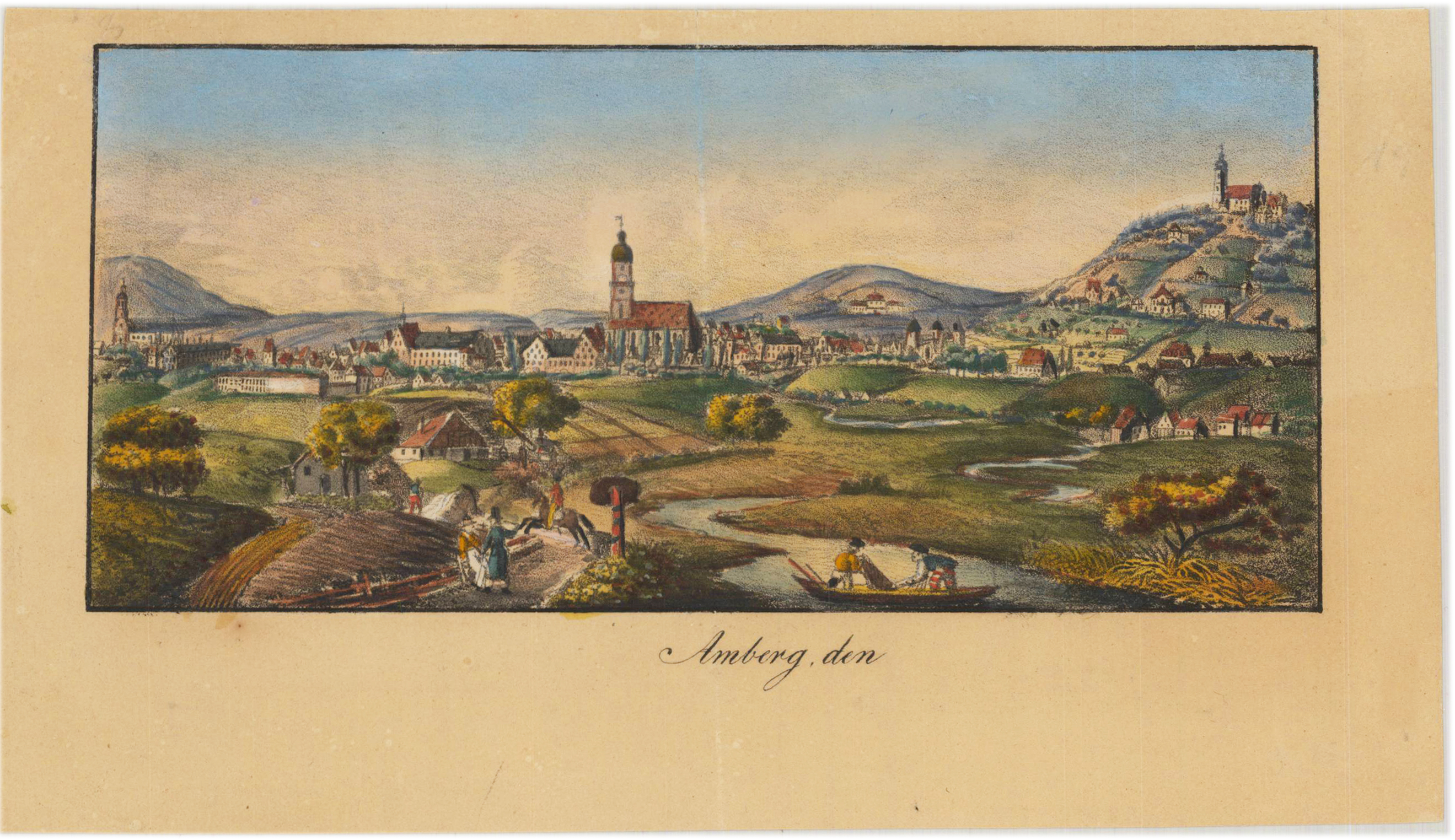
Altkolorierte Lithographien um 1830. Die beiden reizenden alktkolorierten Steindrucke (Lithographien) sind wohl um 1820-30 als Kopfschmuck für Briefpapier entstanden. Äußerst dekorative Darstellungen in schönem Kolorit der Zeit. I. Gezeigt wird Amberg von Süden, im Vordergrund die Vils mit reizender Biedermeierstaffage Im Hintergrund der die Wallfahrtskirche Mariahilf. 2. Ansicht des Marktplatzes mit figürlicher Biedermeierstaffage und die Wallfahrtskirche Mariahilf im Hinterfreund.
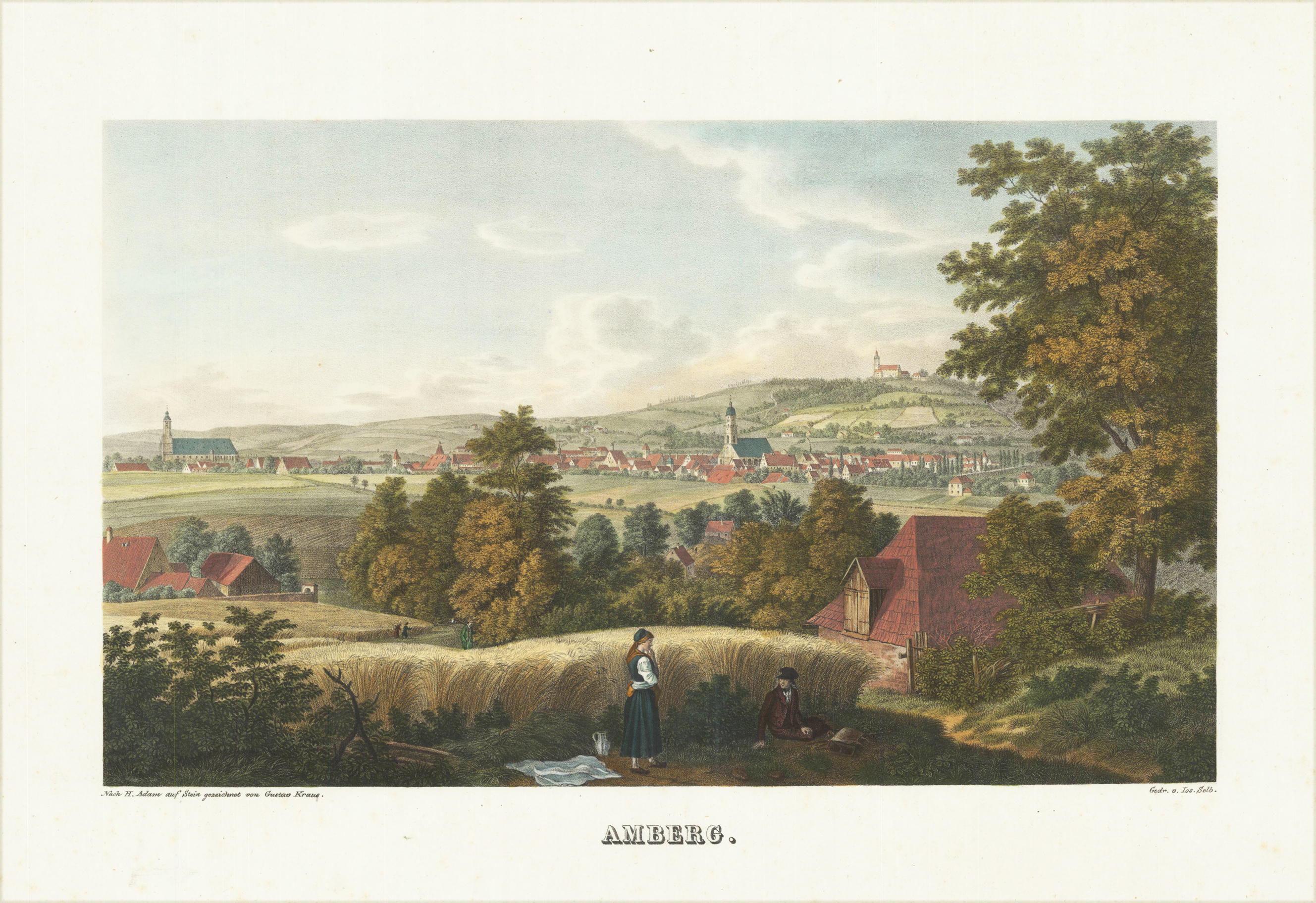
Original Steindruck nach einer Zeichnung von Gustav Kraus, handkoloriert. Prächtige Ansicht der Stadt Amberg in der Oberpfalz, erschienen in der berühmten Serie "Ansichten bayerischer Städte" von Gustav Kraus.
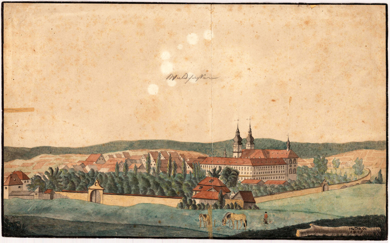
Zeichnung in Aquarellfarben um 1817. Darstellung des Ortes Waldsassen mit dem Kloster Waldsassen nebst umliegender Umgebung, sowie Feldern und Wäldern im Hintergrund. Signiert rechts unten: Hautmann 1817. Rückseitig mit Handschriftlichem Hinweis: Michael Hautmann, Geburtsort Waldsassen
Original Kupferstichkartein zeitgenössischem Grenz- und Flächenkolorit. Dargestellt wird die Oberpfalz um 1716/20 eingeteilt in seine einzelnen politischen Kreise. Im Süden Regensburg mit der Donau, reicht hin bis zum nördl. Fichtelgebirge. Detaillierte Karte mit vielen Ortsangaben, Flüssen, Weilern, etc. Tadellos erhalten.
Original lavierte Tuschfederzeichnung. Signiert und datiert ,G. Steinlein 1942'. Beim Zeichner dieser feinen lavierten Tuschfederzeichnung der Burg Runding in der Oberpfalz handelt es sich um den süddeutschen Architekten Gustav Steinlein. handeln. Steinlein schuf diese Zeichnung nach dem Entwurf von Würthle, dieser erschien erstmals als Stahlstichillustration um 1845-50 in der bayr. Landesbeschreibung ,Das Königreich Bayern'. Der Zeichner und Architekt Gustav Steinlein war mapgeblich als Illustrator in dem Werk ,Die Baukunst Alt-Münchens' beteiligt.
Original woodcut map (no. 6) published in Philipp Apian's atlas ,Chorographia Bavariae - Bairische Landtaflen'. The Apian map of Bavaria was an extraordinary achievement. As a survey based on triangulation, it was quite precocious; as a topographic survey of an entire country and as a model of modern topographic maps issued in uniform sheets, it was the first. Its inherent accuracy and detail ensured that it would remain a useful map, in different guises, for a very long time indeed. (Karrow) The child prodigy Philipp Apian took over the chair of Mathematics at Ingolstadt University in 1552 upon the death of his father at 21 years old. Two years later he received a commission from Duke Albrecht V to undertake a survey of Bavaria in order to make a map. After the next seven years Apian's map with lovely colours was ready. It measured 500 x 500 centimetres! The original was lost around 1782 but copies were made during the eighteenth century and just a small number survive in the Bavarian Land Survey Office. Duke Albrecht was pleased with his stunning map but desired something more manageable. He ordered Apain to make it somewhat smaller, put it in a special porfolio and publish it, this is the work we offer here. To quote Karrow 'The first sheets of this map were published in Munich as early as 1566. Evidently the work there did not progress as he wished, and Apain himself transferred the finishing of additional woodblocks and the printing to the printing shop inherited from his father in Ingolstadt.' The elaborate woodcutting was done by Jost Amman and Gradierer von Zürich, whose initial appears ath the bottom edge of sheet 22. More normal work was done by Wolf Strauss and HF (unidentified), whose monograms appeared at the lower right hand corner of sheet 24 below the date 1567. Neither of these last two monograms appear here. The original woodblocks still survive in the Bayerisches Nationalmuseum.
Original antique copper engraving in full contemporary hand color in wash and outline when published. Im rechten Bildrand mittig floral eingefasste Titelkartusche, sowie rechts oben Insetkarte mit der Fossa Carolina bei Dietfurt a.d. Altmühl. Historische Karte des Nordgaus nach der Zeichnung von Johann Heinrich v. Falckenstein. Johann Baptist Homann (20 March 1664 – 1 July 1724) was a German geographer and cartographer, who also made maps of the Americas. Homann was born in Oberkammlach near Kammlach in the Electorate of Bavaria. Although educated at a Jesuit school, and preparing for an ecclesiastical career, he eventually converted to Protestantism and from 1687 worked as a civil law notary in Nuremberg. He soon turned to engraving and cartography; in 1702 he founded his own publishing house. Homann acquired renown as a leading German cartographer, and in 1715 was appointed Imperial Geographer by Emperor Charles VI. Giving such privileges to individuals was an added right that the Holy Roman Emperor enjoyed. In the same year he was also named a member of the Prussian Academy of Sciences in Berlin. Of particular significance to cartography were the imperial printing privileges (Latin: privilegia impressoria). These protected for a time the authors in all scientific fields such as printers, copper engravers, map makers and publishers. They were also very important as a recommendation for potential customers. In 1716 Homann published his masterpiece Grosser Atlas ueber die ganze Welt (Grand Atlas of all the World). Numerous maps were drawn up in cooperation with the engraver Christoph Weigel the Elder, who also published Siebmachers Wappenbuch. Homann died in Nuremberg in 1724. He was succeeded by his son Johann Christoph (1703-1730). The company carried on upon his death as Homann heirs company, managed by Johann Michael Franz and Johann Georg Ebersberger. After subsequent changes in management the company folded in 1852.[1] The company was known as "Homann Erben", "Homanniani Heredes", or "Heritiers de Homann" abroad. (Wikipedia)
Original engraved map, hand colored in the period. Published in Joan & Guiljelmus Blaeu's atlas ,Theatrum' ca. 1643-50 in Amsterdam. In the lower part of the map with a fine decorative hand colored title cartouche. The map depicts the so-called ,Palatinatus Bavariae' the ,Obere Pfalz'. The southern border on the map shows Regensburg at the northest point on the river Danube and extends northwest towards the neighbouring Franconia and in the east the Bohemian woods towards the Czech Republic. In the north towards Eschenbach and Parkstein.
Copper engraving, uncolored as published. Published for the 1st time 1633 and in various atlas editions with Joan Janssonius until 1680. This example was published around 1638/49. The maps shows upper Bavaria with the neighboring Bohemia woods, the 'Fichtelgebirge' and Nürnberg. In the south the course of the Danube. In the lower part of the map with a fine decorative title cartouche with coat of arms. The map depicts the so-called ,Palatinatus Bavariae' the ,Obere Pfalz'. The southern border on the map shows Regensburg at the northest point on the river Danube and extends northwest towards the neighbouring Franconia and in the east the Bohemian woods towards the Czech Republic. In the north towards Eschenbach and Parkstein.
Original engraved map, hand colored in the period. Published in Joan & Guiljelmus Blaeu's atlas ,Theatrum' ca. 1643-50 in Amsterdam. In the lower part of the map with a fine decorative hand colored title cartouche. The map depicts the so-called ,Palatinatus Bavariae' the ,Obere Pfalz'. The southern border on the map shows Regensburg at the northest point on the river Danube and extends northwest towards the neighbouring Franconia and in the east the Bohemian woods towards the Czech Republic. In the north towards Eschenbach and Parkstein. Joan Blaeu (23 September 1596 – 21 December 1673) was a Dutch cartographer born in Alkmaar, the son of cartographer Willem Blaeu. In 1620 he became a doctor of law but he joined the work of his father. In 1635 they published the Atlas Novus (full title: Theatrum orbis terrarum, sive, Atlas novus) in two volumes. Joan and his brother Cornelius took over the studio after their father died in 1638. Joan became the official cartographer of the Dutch East India Company. Blaeu's world map, Nova et Accuratissima Terrarum Orbis Tabula, incorporating the discoveries of Abel Tasman, was published in 1648. This map was revolutionary in that it "depicts the solar system according to the heliocentric theories of Nicolaus Copernicus, which show the earth revolving around the sun.... Although Copernicus's groundbreaking book On the Revolutions of the Spheres had been first printed in 1543, just over a century earlier, Blaeu was the first mapmaker to incorporate this revolutionary heliocentric theory into a map of the world." Blaeu's map was copied for the map of the world set into the pavement of the Groote Burger-Zaal of the new Amsterdam Town Hall, designed by the Dutch architect Jacob van Campen (now the Amsterdam Royal Palace), in 1655. Blaeu's Hollandia Nova was also depicted in his Archipelagus Orientalis sive Asiaticus published in 1659 in the Kurfürsten Atlas (Atlas of the Great Elector). and used by Melchisédech Thévenot to produce his map, Hollandia Nova—Terre Australe (1664). As Joan Blaeu, he also published the 12 volume "Le Grand Atlas, ou Cosmographie blaviane, en laquelle est exactement descritte la terre, la mer, et le ciel". One edition is dated 1663. That was folio (540 x 340 mm), and contained 593 engraved maps and plates. In March 2015, a copy was on sale for £750,000. Around 1649 Joan Blaeu published a collection of Dutch city maps named Toonneel der Steeden (Views of Cities). In 1651 he was voted into the Amsterdam council. In 1654 Joan published the first atlas of Scotland, devised by Timothy Pont. In 1662 he reissued the Atlas Novus, also known as Atlas Maior, in 11 volumes, and one for oceans.[citation needed] A cosmology was planned as their next project, but a fire destroyed the studio completely in 1672. (Wikipedia)
Copper engraving, published in a Latin edition of the 'Theatrum Orbis Terrarum' by Abraham Ortelius around 1595. Decorative and fine map of the 'Palatinatus Bavariae' around 1595. The maps shows upper Bavaria with the neighboring Bohemia woods, the 'Fichtelgebirge' and Nürnberg. In the south the course of the river Danube. The cartographic source for this map received Ortelius from Erhard Reych. The cities and towns on the map still shown as miniature views in form of silhouettes. From 1584 onwards Ortelius changed the title cartouche from the top to the bottom of the map.
Original Kupferstichkarte, in dekorativem Grenz- und Flächenkolorit. Erschienen in dem Atlas,Theatrum Orbis Terrarum' von Abraham Ortelius in Antwerpen bei Platin. Im Unterrand mit ausgemalter Rollwerkskartusche. Dekorative und schöne Karte der Oberpfalz um 1575. Die Landkarte zeigt die Oberpfalz mit angrenzendem Böhmerwald, Fichtelgebirge u. Nürnberg. Im Süden noch mit dem Lauf der Donau. Ortelius übernahm die Karte nach der Zeichnung von Erhard Reych. Die Orte noch in Silhouettenform als Miniaturansichten dargestellt. Schönes Exemplar. Erschien erstmals 1570 und nur bis 1581 in dieser Variante mit der Titelkartusche im Oberrand.
Copper, engraving decorative handcolored in wash and outline, published in the Theatrum Orbis Terrarum by Abraham Ortelius. At the bottom the colored title cartouche. Decorative and fine map of the Palatinatus Bavariae around 1584-1612. The maps shows upper Bavaria with the neighboring Bohemia woods, the Fichtelgebirge and Nürnberg. In the south the course of the Danube. The cartographic source for this map received Ortelius from Erhard Reych. The cities and town on the map still shown as miniature views in form of silhuetes. This version with the cartouche at the bottom was published 1584 for the first time. Kupferstichkarte, in dekorativem Flächenkolorit, erschienen im Theatrum Orbis Terrarum von A. Ortelius bei Juan Baptist Vrients. Im Unterrand mit ausgemalter Rollwerkskartusche. Dekorative und schöne Karte der Oberpfalz um 1584/1612.Zeigt die Oberpfalz mit angrenzendem Böhmerwald, Fichtelgebirge u. Nürnberg. Im Süden noch mit dem Lauf der Donau. Ortelius übernahm die Karte nach der Zeichnung von Erhard Reych. Die Orte noch in Silhouettenform als Miniaturansichten dargestellt. Tadelloses Exemplar. Erschien erstmals ab 1584 in dieser Variante mit der Titelkartusche im Unterrand.
Original antique copper engraving in decorative hand color in wash and outline, published in the Theatrum Orbis Terrarum by Abraham Ortelius. At the bottom the colored title cartouche. Decorative and fine map of the Palatinatus Bavariae around 1584-1612. The maps shows upper Bavaria with the neighboring Bohemia woods, the Fichtelgebirge and Nürnberg. In the south the course of the Danube. The cartographic source for this map received Ortelius from Erhard Reych. The cities and town on the map still shown as miniature views in form of silhuetes. This version with the cartouche at the bottom was published 1584 for the first time. Ortelius was born on 14 April 1527 in the city of Antwerp, which was then in the Habsburg Netherlands (modern-day Belgium). The Orthellius family were originally from Augsburg, a Free imperial city of the Holy Roman Empire. In 1535, the family had fallen under suspicion of Protestantism. Following the death of Ortelius's father, his uncle Jacobus van Meteren returned from religious exile in England to take care of Ortelius. Abraham remained close to his cousin Emanuel van Meteren, who would later moved to London. In 1575 he was appointed geographer to the king of Spain, Philip II, on the recommendation of Arias Montanus, who vouched for his orthodoxy. He travelled extensively in Europe and is specifically known to have traveled throughout the Seventeen Provinces; in southern, western, northern, and eastern Germany (e.g., 1560, 1575–1576); France (1559–1560); England and Ireland (1576); and Italy (1578, and perhaps twice or thrice between 1550 and 1558). Beginning as a map-engraver, in 1547 he entered the Antwerp Guild of Saint Luke as an illuminator of maps. He supplemented his income trading in books, prints, and maps, and his journeys included yearly visits to the Frankfurt book and print fair, where he met Gerardus Mercator in 1554. In 1560, however, when travelling with Mercator to Trier, Lorraine, and Poitiers, he seems to have been attracted, largely by Mercator's influence, towards the career of a scientific geographer. (Wikipedia)
Copper engraving, hand colored in outline and wash when published. Ornated in the upper right corner with an allegoric title cartouche, the Bavarian lion and a coat of arms. The map shows the 'Upper Palatinates' of Bavaria divided up into its single political circles. In the south we find Regensburg at the Northeast point of the Danube, in the north the map extends towards the 'Fichtelgebirge' . The map itself is very accurate and provides information on small place names, villages, monasteries, woods, lakes, rivers, etc.
Original antique copper engraving, uncolored as published. A highly decorative early map of the so-called ,Oberpfalz', the region north of the river Danube towards the neighboring Franconia and Bohemia. Equipped with a renaissance title cartouche next to it a small mileage scale. Larger place names highlighted as miniature city views as well colored in red. The map has many engraved place names, rivers, lakes, woods and mountains as well. Gerardus Mercator (5 March 1512 – 2 December 1594) was a 16th-century geographer, cosmographer and cartographer from the County of Flanders. He is most renowned for creating the 1569 world map based on a new projection which represented sailing courses of constant bearing (rhumb lines) as straight lines—an innovation that is still employed in nautical charts. Mercator was one of the pioneers of cartography and is widely considered the most notable figure of the school in its golden age (approximately 1570s–1670s). In his own day, he was a notable as maker of globes and scientific instruments. In addition, he had interests in theology, philosophy, history, mathematics and geomagnetism. He was also an accomplished engraver and calligrapher. Unlike other great scholars of the age he travelled little and his knowledge of geography came from his library of over one thousand books and maps, from his visitors and from his vast correspondence (in six languages) with other scholars, statesmen, travellers, merchants and seamen. Mercator's early maps were in large formats suitable for wall mounting but in the second half of his life, he produced over 100 new regional maps in a smaller format suitable for binding into his Atlas of 1595. This was the first appearance of the word Atlas in reference to a book of maps. However, Mercator used it as a neologism for a treatise (Cosmologia) on the creation, history and description of the universe, not simply a collection of maps. He chose the word as a commemoration of the Titan Atlas, "King of Mauretania", whom he considered to be the first great geographer. A large part of Mercator's income came from sales of his terrestrial and celestial globes. For sixty years they were considered the finest in the world, and were sold in such great numbers that there are many surviving examples. This was a substantial enterprise involving the manufacture of the spheres, printing the gores, building substantial stands, packing and distributing all over Europe. He was also renowned for his scientific instruments, particularly his astrolabes and astronomical rings used to study the geometry of astronomy and astrology. Mercator wrote on geography, philosophy, chronology and theology. All of the wall maps were engraved with copious text on the region concerned. As an example the famous world map of 1569 is inscribed with over five thousand words in fifteen legends. The 1595 Atlas has about 120 pages of maps and illustrated title pages but a greater number of pages are devoted to his account of the creation of the universe and descriptions of all the countries portrayed. His table of chronology ran to some 400 pages fixing the dates (from the time of creation) of earthly dynasties, major political and military events, volcanic eruptions, earthquakes and eclipses. He also wrote on the gospels and the old testament. Mercator was a devout Christian born into a Catholic family at a time when Martin Luther's Protestantism was gaining ground. He never declared himself as a Lutheran but he was clearly sympathetic and he was accused of heresy by Catholic authorities; after six months in prison he was released unscathed. This period of persecution is probably the major factor in his move from Catholic Leuven (Louvain) to a more tolerant Duisburg, in the Holy Roman Empire, where he lived for the last thirty years of his life. Walter Ghim, Mercator's friend and first biographer, describes him as sober in his behaviour, yet cheerful and witty in company, and never more happy than in debate with other scholars. Above all he was pious and studious until his dying days. (Wikipedia)
Lithographie, unkoloriert mit eingezeichneten Truppenformationen. Detaillerte Karte der napoleonischen Schlacht bei Eggmühl am 22. April 1809. Die Karte zeigt detaillert das Gebiet südlich Regensburg von Schierling und Eggmühl über Thalmassing, Bad Abbach, Mintraching bis hin nach Barbing und Oberisling südlich von Regensburg mit den eingezeichneten Truppenformationen der Franzosen und Österreicher. Mit vielen Details von eingezeichneten Wäldern, Bächen, Flüssen, Dörfern, Weilern, Wegen und Straßen.
Original Kupferstich, unkoloriert, erschienen in der ersten Ausgabe der bayrischen Landesbeschreibung von Michael Wening. Prachtvolle Darstellung von Schloß Alteglofsheim bei Regensburg mit seinen prachtvollen barocken Gärten von Westen aus gesehen, im Süden verschiedene benachbarte Gebäude, wohl des alten Alteglofsheim. Links oben mit dem Wappen des Reichsgrafen Johann Georg II. von Königsfeld, der 1728 bis 1734 den Garten, die Fassade, den Südflügel neu gestalten ließ. Dabei wirkten Johann Baptist Zimmermann und François de Cuvilliés mit. Michael Wening, geboren am 11. Juli 1645 in Nürnberg, wurde 1675 in München zum Hofkupferstecher ernannt. Michael Wening erlangte Bekanntheit durch seine großformatigen Kupferstiche zu den Türkenkriegen, welche er für Kurfürst Max Emanuel anfertigte. Vom selbigen erhielt er im Jahre 1696 den Auftrag Ansichten aller bayrischen Orte und Klöster als Kupferstiche anzufertigen. Er beschloß dies in in 4 Kupferstichwerken, nämlich illustrierte Beschreibungen der vier Rentämter von Bayern herauszugeben. Das Rentamt München, Burghausen, Landshut und Straubing. Im Jahre 1692 begann er mit diesem Auftrag und vollendete 1701 ,Das Rentamt München', den ersten Band des vierbändigen Werkes ,Historico-topographica descriptio Bavariae'. Bis zum Jahre 1726 folgten die anderen drei Bände der Rentämter Burghausen, Landshut und Straubing. Insgesamt umfasste sein Werk nach Vollendung über 1000 verschiedene Abbildungen von bayerischen Städten, Märkten, Dörfern, Schlössern und Klöstern. Der begleitende Text wurde von dem Jesuiten Ferdinand Schönwetter geschrieben. Michael Wening verstarb im April 1718 in München.
Original Kupferstich, unkoloriert, erschienen in der ersten Ausgabe der bayrischen Landesbeschreibung von Michael Wening. Prachtvolle Darstellung von Schloß Alteglofsheim mit seinen Nebengebäuden, von Osten ausgesehen, hinweg über die gesamte barocke Gartenanlage des Schloßes Alteglofsheim. Links oben mit dem Wappen des Reichsgrafen Johann Georg II. von Königsfeld, der 1728 bis 1734 den Garten, die Fassade, den Südflügel neu gestalten ließ. Dabei wirkten Johann Baptist Zimmermann und François de Cuvilliés mit. Michael Wening, geboren am 11. Juli 1645 in Nürnberg, wurde 1675 in München zum Hofkupferstecher ernannt. Michael Wening erlangte Bekanntheit durch seine großformatigen Kupferstiche zu den Türkenkriegen, welche er für Kurfürst Max Emanuel anfertigte. Vom selbigen erhielt er im Jahre 1696 den Auftrag Ansichten aller bayrischen Orte und Klöster als Kupferstiche anzufertigen. Er beschloß dies in in 4 Kupferstichwerken, nämlich illustrierte Beschreibungen der vier Rentämter von Bayern herauszugeben. Das Rentamt München, Burghausen, Landshut und Straubing. Im Jahre 1692 begann er mit diesem Auftrag und vollendete 1701 ,Das Rentamt München', den ersten Band des vierbändigen Werkes ,Historico-topographica descriptio Bavariae'. Bis zum Jahre 1726 folgten die anderen drei Bände der Rentämter Burghausen, Landshut und Straubing. Insgesamt umfasste sein Werk nach Vollendung über 1000 verschiedene Abbildungen von bayerischen Städten, Märkten, Dörfern, Schlössern und Klöstern. Der begleitende Text wurde von dem Jesuiten Ferdinand Schönwetter geschrieben. Michael Wening verstarb im April 1718 in München.
Original Stahlstich, gedruckt und verlegt um 1845 in Leipzig, erschienen in der Kunstanstalt von A. H. Payne. Gestochen von Payne nach einer Vorzeichnung von H. Schönfeld. Dargestellt wird die Innenansicht der Walhalla bei Regensburg. Ab 1807 die Idee für einen Gedächtnisort, an dem verdiente deutschsprachige Männer und Frauen gewürdigt werden sollten. Unter Einfluss des Historikers Johannes von Müller, der auch eine erste Auswahl zu ehrender Persönlichkeiten traf, wurde der Name »Walhalla« mit Bezug auf das gleichnamige Kriegerparadies der germanischen Mythologie gewählt.
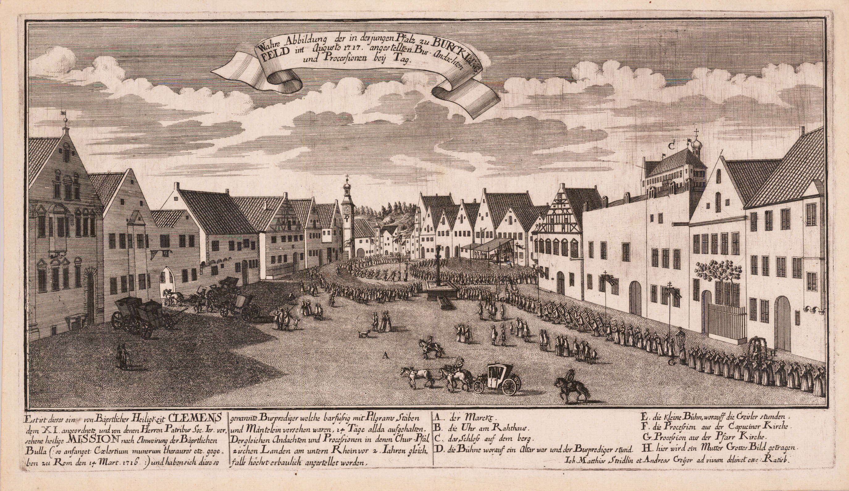
Original Kupferstich, unkoloriert. Gezeichnet und verlegt von Matthias Steidlin und Andreas Geyer in Regensburg, wohl gestochen von A. Geyer. Dargestellt wird die Bußandacht und die Doppelprozession aus Anlass der von Papst Clemens XI. angeordneten heiligen Mission am Marktplatz in Burglengenfeld im August 1717. Aüßerst seltene Einzelpublikation, wahrscheinlich als Flugblatt erschienen. Die Kupferstiche von Matthias Steidlin zu den Burglengenfelder Bußprozessionen im August 1717 werden detailliert erläutert von Manfred Knedlitz in seinem Artikel , ... zum Trost und Nutzen der eingepfarrten Seelen - Passionsspiele und Karfreitagsprozessionen in der mittleren Oberpfalz': ,Einen anschaulichen Eindruck von dem Prozessionsgeschehen in Burglengenfeld vermitteln zwei zeitgenössische Stiche, die Johann Matthias Steidlin und Andreas Geyer im Jahr 1717 fertigten. Auf der 'Wahren Abbildung der ... nächtlichen Busandachten und Processionen' sind unter anderem 'Männer mit aus gespannten Armen', 'Creutzschleiffer' und 'Geisler' zu sehen; die andere Ansicht ('bey Tag') zeigt zwei Prozessionszüge, die aus der Pfarrkirche bzw. der Kapuzinerkirche kommend auf eine überdachte Bühne zustreben, 'worauf ein Altar war und der Busprediger stund'; zu erkennen sind auch eine 'kleine Bühne, worauff die Geisler stunden' und die Träger eines Marienbildes. Mit welchen dramatischen Effekten die mitziehenden Gläubigen im Bann gehalten wurden, zeigt ein Bericht des Pfarrers Johann Michael Schnitter aus Hohenfels. Als Spielleiter hatte er folgende Idee entwickelt : Während sich die Prozession steilnehmer durch den Ort bewegten, sollte 'in der Eill an Kirchenthurm ein Creuz aufgericht , und darauf ein Schulknab von 12 Jahren jedoch ohne Gefahr gebundten'.