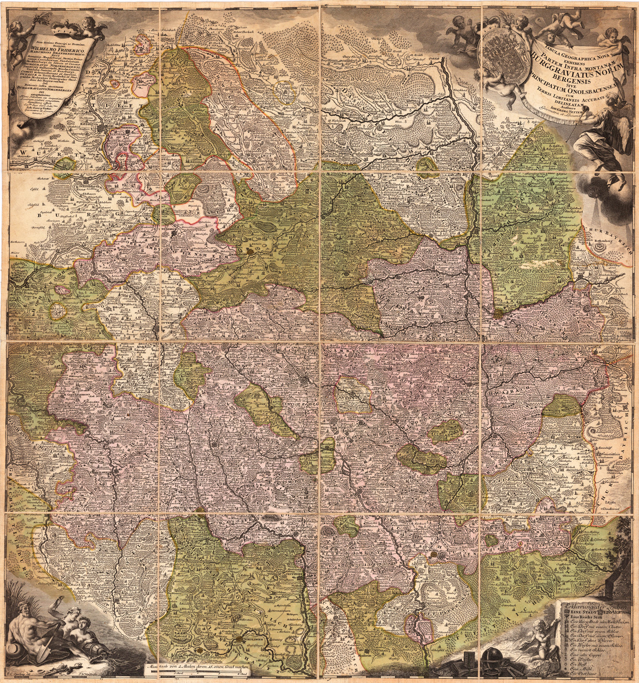
Kupferstichkarte, in zeitgenöss. Grenz- u. Flächenkolorit. Falt- u. Reisekarte, in 16 Teilen segmentiert u. auf Leinen montiert. Rechts oben große, allegor. Titelkartusche, links eine Kartusche mit Widmung auf Herzog Wilhelm Friedrich, unten Kartuschen mit Legende u. Allegorie auf d. Flüsse.
Originaler Doppelseiten-Holzschnitt aus der berühmten Nürnberger Chronik, gedruckt in Nürnberg im Juli 1493. Lateinische Textausgabe. Diese Ansicht von Bamberg ist eine der frühesten erhältlichen authentischen Stadtansichten dieser Stadt, die nur wenige Jahre vor 1500 veröffentlicht wurde. Diese Platte wurde genau im Juli 1493 in Nürnberg bei Koberger veröffentlicht und gedruckt, wo die 'Nürnberger Chronik' veröffentlicht und gedruckt wurde . Die Stadt Bamberg war in dieser Zeit ein wichtiger Marktplatz für Kaufleute in Deutschland und Mitteleuropa, sie war und ist auch eine wichtige Bischofsresidenz. Auch aus diesem Grund war die Stadtansicht von Bamberg ziemlich groß und gut ausgeführt und ist auch eine der größten Doppelseitenansichten der „Nürnberger Chronik“. Die „Nürnberger Chronik“ war die früheste und am reichsten illustrierte Inkunabel und Beschreibung der Welt, die auch mit einer kleinen Anzahl authentischer Doppelseiten-Stadtansichten illustriert wurde. Die Holzschnitte wurden größtenteils von Pleydenwurff geschnitten.
Diese Ansicht von Bamberg ist eine der frühesten erhältlichen authentischen Stadtansichten dieser Stadt, die nur wenige Jahre vor 1500 veröffentlicht wurde. Diese Platte wurde genau im Juli 1493 in Nürnberg bei Koberger veröffentlicht und gedruckt, wo die 'Nürnberger Chronik' veröffentlicht und gedruckt wurde . Die Stadt Bamberg war in dieser Zeit ein wichtiger Marktplatz für Kaufleute in Deutschland und Mitteleuropa, sie war und ist auch eine wichtige Bischofsresidenz. Auch aus diesem Grund war die Stadtansicht von Bamberg ziemlich groß und gut ausgeführt und ist auch eine der größten Doppelseitenansichten der „Nürnberger Chronik“.
Die „Nürnberger Chronik“ war die früheste und am reichsten illustrierte Inkunabel und Beschreibung der Welt, die auch mit einer kleinen Anzahl authentischer Doppelseiten-Stadtansichten illustriert wurde. Die Holzschnitte wurden größtenteils von Pleydenwurff geschnitten.
Original antiker Kupferstich in zeitgenössischem Grenzkolorit. Eine seltene und schöne Karte von Franken in Deutschland. Franken war eine Verwaltungseinheit im Heiligen Römischen Reich, bevor 1871 der moderne Staat Deutschland gegründet wurde. Diese Karte wurde ursprünglich in Robert de Vaugondys Atlas Portatif Unviversel et Militaire herausgegeben. Gilles Robert de Vaugondy (1688–1766), auch bekannt als Le Sieur oder Monsieur Robert, und sein Sohn Didier Robert de Vaugondy (ca. 1723–1786) waren im 18. Jahrhundert führende Kartographen in Frankreich. 1757 veröffentlichten Gilles und Didier Robert De Vaugondy das Atlas Universel, einen der wichtigsten Atlanten des 18. Jahrhunderts. Um den Atlas zu erstellen, haben die Vaugondys ältere Quellen in modernere Vermessungskarten integriert. Sie verifizierten und korrigierten den Breiten- und Längengrad vieler regionaler Karten im Atlas mit astronomischen Beobachtungen. Das ältere Material wurde mit vielen neuen Ortsnamen überarbeitet. 1760 wurde Didier Robert de Vaugondy zum Geographen Ludwigs XV. Ernannt. Gilles und Didier Robert De Vaugondy produzierten ihre Karten und Erdkugeln als Vater und Sohn. Globen in verschiedenen Größen wurden hergestellt, indem mit Kupferplatten bedruckte Gores auf einen verputzten Pappmaché-Kern geklebt wurden, ein komplizierter und teurer Herstellungsprozess, bei dem mehrere Spezialisten beschäftigt waren. In einigen Fällen ist es ungewiss, ob Gilles oder Didier eine bestimmte Karte erstellt haben. Gilles signierte Karten oft als "M.Robert", während Didier seine Karten häufig als "Robert de Vaugondy" signierte oder nach seinem Namen "fils" oder "filio" hinzufügte. Die Robert de Vaugondys stammten von der Familie Nicolas Sanson durch Sansons Enkel Pierre Moulard-Sanson ab. Von ihm erbten sie einen Großteil von Sansons kartografischem Material, das sie mit Karten und Tafeln kombinierten, die nach Hubert Jaillots Tod im Jahre 1712 erworben wurden, um die Grundlage für das Atlas Universel zu bilden. Für ihre Karten von Kanada und Südamerika wurden Quellen aus dem Dépôt de la Marine verwendet, dem offiziellen französischen Aufbewahrungsort für maritime Informationen. Wie Ortelius und Mercator haben die Vaugondys ihre Quellen gutgeschrieben, was dem Studium der Geschichte der Kartographie in dieser Zeit sehr zugute gekommen ist. (Wikipedia)
Original antike Kupferstichkarte in zeitgenöss. Grenz- u. Flächenkolorit. Dargestellt wird der Fränkische Kreis, im Norden von Hattenburg bis Ingolstadt im Süden. Im Westen von Würzburg bis Eger im Osten. Rechts oben mit großer figürlicher dekorativ ausgestatteter Titelkartusche.
Original antique copper engraving, hand colored in outline and wash when published. The map shows the area between Marburg in the north to Stuttgart in the south. Andrernach near Coblenz in the west to Krautheim in the east. In the lower left corner a monument with an inscription and signs accompanied by allegorical figures, in a map frame geographical coordinates. Johann Christoph Weigel, known as Christoph Weigel the Elder (9 November 1654 – 5 February 1725), was a German engraver, art dealer and publisher. He was born at Redwitz, Free imperial city of Eger in Egerland, and died in Nuremberg, aged 70. The cartographer Weigel worked around 1719 in Nürnberg and his maps are showing the typical style of this period in map making in Southern German. He worked very close as with Johann B. Homann in Nürnberg. All his maps were hand colored in outline and decorative body color immediatelly in his printing house, after they were printed.
Antike Kupferstichkarte in zeitgenössischem Grenz- und Flächenkolorit. Die schöne, altkolorierte Karte zeigt den gesamten Fränkische Kreis mit dem Gebiet zwischen Schmalkalden im Norden, Pfreimd, Pappenheim und Eichstätt im Süden und Mainz im Westen. Im Mittelpunkt ist Würzburg.
Copper engraving, uncolored as published. This fine engraving was published in Gabriel Bodenehr's famous serious "Europeans Macht und Pracht", a series of engravings depicting city views, plans, fortresses and castles in Europe. Many plates often are showing fortifications in Hungary and Southeast Europe, Spain, Belgium, Austria and Germany. Gabriel Bodenehr was during this period a successful publisher for maps and prints in Augsburg in Southern Germany.
Woodcut published 1628 in the Cosmographia by Sebastian Münster, printed on the full text sheet. Early and decorative map of Franconia. City views are shown as miniature views. Sebastian Münster (20 January 1488 – 26 May 1552) was a German cartographer, cosmographer, and a Christian Hebraist scholar. His work, the Cosmographia from 1544, was the earliest German description of the world.He was born in Ingelheim, near Mainz, the son of Andreas Münster. His parents and other ancestors were farmers. In 1505, he entered the Franciscan order. Four years later, he entered a monastery where he became a student of Konrad Pelikan for five years. Münster completed his studies at the University of Tübingen in 1518. His graduate adviser was Johannes Stöffler. He left the Franciscans for the Lutheran Church in order to accept an appointment at the Reformed Church-dominated University of Basel in 1529.He had long harboured an interest in the Lutherans, and during the German Peasants' War, as a monk, he had been repeatedly attacked. A professor of Hebrew, and a disciple of Elias Levita, he edited the Hebrew Bible (2 vols. fol., Basel, 1534–1535), accompanied by a Latin translation and a large number of annotations. He was the first German to pmmatica Chaldaica (Basel, 1527). His lexicographical labours included a Dictionarium Chaldaicum (1527), and a Dictionarium trilingue for Latin, Greek, and Hebrew in 1530. He released a Mappa Europae (map of Europe) in 1536. In 1537 he published a Hebrew Gospel of Matthew which he had obtained from Spanish Jews he had converted. In 1540 he published a Latin edition of Ptolemy's Geographia with illustrations. The 1550 edition contains cities, portraits, and costumes. These editions, printed in Germany, are the most valued of this work. Other writings that followed are Horologiographia (a treatise on dialling – constructing sundials, Basel, 1531), and Organum Uranicum (a treatise on the planetary motions, 1536). His Cosmographia of 1544 was the earliest German-language description of the world. It had numerous editions in different languages including Latin, French, Italian, English, and even Czech. The Cosmographia was one of the most successful and popular works of the 16th century. It passed through 24 editions in 100 years.[6] This success was due to the fascinating woodcuts (some by Hans Holbein the Younger, Urs Graf, Hans Rudolph Manuel Deutsch, and David Kandel), in addition to including the first to introduce "separate maps for each of the four continents known then – America, Africa, Asia and Europe."[7] It was most important in reviving geography in 16th-century Europe. The last German edition was published in 1628, long after his death. Münster was also known as translator of the Hebrew Bible (Hebraica Biblia). His edition was published in two volumes (1546) in Basel. The first volume contains Genesis-2 Kings, following the order of the Masoretic codices. The second volume contains The Prophets (Major and Minor), The Psalms, Job, Proverb, Daniel, Chronicles, and the Five Scrolls (The Song of Songs, Ruth, Lamentations, Ecclesiastes and Esther). His Rudimenta Mathematica was published in Basel in 1551.[4] He died at Basel of the plague in 1552. His tombstone described him as the Ezra and the Strabo of the Germans.roduce an edition of the Hebrew Bible. He published more than one Hebrew grammar, and was the first to prepare a Gra
Woodcut published 1628 in the Cosmographia by Sebastian Münster, printed on the full text sheet. Early and decorative map of Franconia. City views are shown as miniature views. Sebastian Münster (20 January 1488 – 26 May 1552) was a German cartographer, cosmographer, and a Christian Hebraist scholar. His work, the Cosmographia from 1544, was the earliest German description of the world.He was born in Ingelheim, near Mainz, the son of Andreas Münster. His parents and other ancestors were farmers. In 1505, he entered the Franciscan order. Four years later, he entered a monastery where he became a student of Konrad Pelikan for five years. Münster completed his studies at the University of Tübingen in 1518. His graduate adviser was Johannes Stöffler. He left the Franciscans for the Lutheran Church in order to accept an appointment at the Reformed Church-dominated University of Basel in 1529.He had long harboured an interest in the Lutherans, and during the German Peasants' War, as a monk, he had been repeatedly attacked. A professor of Hebrew, and a disciple of Elias Levita, he edited the Hebrew Bible (2 vols. fol., Basel, 1534–1535), accompanied by a Latin translation and a large number of annotations. He was the first German to pmmatica Chaldaica (Basel, 1527). His lexicographical labours included a Dictionarium Chaldaicum (1527), and a Dictionarium trilingue for Latin, Greek, and Hebrew in 1530. He released a Mappa Europae (map of Europe) in 1536. In 1537 he published a Hebrew Gospel of Matthew which he had obtained from Spanish Jews he had converted. In 1540 he published a Latin edition of Ptolemy's Geographia with illustrations. The 1550 edition contains cities, portraits, and costumes. These editions, printed in Germany, are the most valued of this work. Other writings that followed are Horologiographia (a treatise on dialling – constructing sundials, Basel, 1531), and Organum Uranicum (a treatise on the planetary motions, 1536). His Cosmographia of 1544 was the earliest German-language description of the world. It had numerous editions in different languages including Latin, French, Italian, English, and even Czech. The Cosmographia was one of the most successful and popular works of the 16th century. It passed through 24 editions in 100 years.[6] This success was due to the fascinating woodcuts (some by Hans Holbein the Younger, Urs Graf, Hans Rudolph Manuel Deutsch, and David Kandel), in addition to including the first to introduce "separate maps for each of the four continents known then – America, Africa, Asia and Europe."[7] It was most important in reviving geography in 16th-century Europe. The last German edition was published in 1628, long after his death. Münster was also known as translator of the Hebrew Bible (Hebraica Biblia). His edition was published in two volumes (1546) in Basel. The first volume contains Genesis-2 Kings, following the order of the Masoretic codices. The second volume contains The Prophets (Major and Minor), The Psalms, Job, Proverb, Daniel, Chronicles, and the Five Scrolls (The Song of Songs, Ruth, Lamentations, Ecclesiastes and Esther). His Rudimenta Mathematica was published in Basel in 1551.[4] He died at Basel of the plague in 1552. His tombstone described him as the Ezra and the Strabo of the Germans.roduce an edition of the Hebrew Bible. He published more than one Hebrew grammar, and was the first to prepare a Gra
Woodcut published 1628 in the Cosmographia by Sebastian Münster, printed on the full text sheet. Early and decorative map of Franconia. City views are shown as miniature views.
Original antique copper engraving, uncolored as published. Copper engraving of the Princely Residence Castle of Würzburg. This fine engraving was published in Gabriel Bodenehr's famous serious "Europeans Macht und Pracht", a series of engravings depicting city views, plans, fortresses and castles in Europe. Many plates often are showing fortifications in Hungary and Southeast Europe, Spain, Belgium, Austria and Germany. Gabriel Bodenehr was during this period a sucessful publisher for maps and prints in Augsburg in Southern Germany. Gabriel Bodenehr the Elder (1664-1758 or 1673-1765) was a German map maker and member of a famous engraver and publisher family of Augsburg. His main work was "Atlas Curieux" first published 1704. He was the son of Johann Georg Bodenehr (1631-1703). Gabriel's son was Gabriel Bodenehr the Younger (1705–1792).
Original antique copper engraving, uncolored as published. Copper engraving of the Juliusspital in Würzburg, Franconia. The Juliusspital is a foundation of the Prince-Bishop Julius Echter von Mespelbrunn from the year 1576. a hospital, a retirement home and a winery. The main building with the representative princely building and a historical park is located on the Juliuspromenade.This fine engraving was published in Gabriel Bodenehr's famous serious "Europeans Macht und Pracht", a series of engravings depicting city views, plans, fortresses and castles in Europe. Many plates often are showing fortifications in Hungary and Southeast Europe, Spain, Belgium, Austria and Germany. Gabriel Bodenehr was during this period a sucessful publisher for maps and prints in Augsburg in Southern Germany. Gabriel Bodenehr the Elder (1664-1758 or 1673-1765) was a German map maker and member of a famous engraver and publisher family of Augsburg. His main work was "Atlas Curieux" first published 1704. He was the son of Johann Georg Bodenehr (1631-1703). Gabriel's son was Gabriel Bodenehr the Younger (1705–1792).
Original antiker Kupferstich in zeitgenössischem Handkolorit. Johann Baptist Homann (20 March 1664 – 1 July 1724) was a German geographer and cartographer, who also made maps of the Americas. Homann was born in Oberkammlach near Kammlach in the Electorate of Bavaria. Although educated at a Jesuit school, and preparing for an ecclesiastical career, he eventually converted to Protestantism and from 1687 worked as a civil law notary in Nuremberg. He soon turned to engraving and cartography; in 1702 he founded his own publishing house. Homann acquired renown as a leading German cartographer, and in 1715 was appointed Imperial Geographer by Emperor Charles VI. Giving such privileges to individuals was an added right that the Holy Roman Emperor enjoyed. In the same year he was also named a member of the Prussian Academy of Sciences in Berlin. Of particular significance to cartography were the imperial printing privileges (Latin: privilegia impressoria). These protected for a time the authors in all scientific fields such as printers, copper engravers, map makers and publishers. They were also very important as a recommendation for potential customers. In 1716 Homann published his masterpiece Grosser Atlas ueber die ganze Welt (Grand Atlas of all the World). Numerous maps were drawn up in cooperation with the engraver Christoph Weigel the Elder, who also published Siebmachers Wappenbuch. Homann died in Nuremberg in 1724. He was succeeded by his son Johann Christoph (1703-1730). The company carried on upon his death as Homann heirs company, managed by Johann Michael Franz and Johann Georg Ebersberger. After subsequent changes in management the company folded in 1852.[1] The company was known as "Homann Erben", "Homanniani Heredes", or "Heritiers de Homann" abroad. (Wikipedia)
Copper engraving published in Allain M. Mallet's description of the world 'Description De L' Univers, Contenant Les Differents Systemes Du Monde, Les Cartes generales & particulieres ...'. French text edition with additional German titles on top. Alain Manesson Mallet (1630-1706) was a French cartographer and engineer. He started his career as a soldier in the army of Louis XIV, became a Sergeant-Major in the artillery and an Inspector of Fortifications. He also served under the King of Portugal, before returning to France, and his appointment to the court of Louis XIV. His military engineering and mathematical background led to his position teaching mathematics at court. His major publications were 'Description de L'Univers' (1683) in 5 volumes, and 'Les Travaux de Mars ou l'Art de la Guerre' (1684) in 3 volumes. His 'Description de L'Universe' contains a wide variety of information, including star maps, maps of the ancient and modern world, and a synopsis of the customs, religion and government of the many nations included in his text. It has been suggested that his background as a teacher led to his being concerned with entertaining his readers. This concern manifests itself in the charming harbor scenes and rural landscapes that he included beneath his description of astronomical concepts and diagrams. Mallet himself drew most of the figures that were engraved for this book.(Wikipedia)
Original Lithographie, unkoloriert. Sehr seltene Darstellung des spektakulären Felsens auf der Luisenburg. Die Luisenburg-Festspiele sind Theaterfestspiele im ältesten Freilichttheater Deutschlands. Sie finden alljährlich vor der Felsenkulisse des größten Felsenlabyrinths Europas nahe der Stadt Wunsiedel im Fichtelgebirge statt, die auch Veranstalter der Festspiele ist. (Wikipedia)
Copper engraving, hand colored in outline when published. Decorative view of the franconian fortress of Rohtenberg. This fine engraving was published in Gabriel Bodenehr's famous serious "Europeans Macht und Pracht", a series of engravings depicting city views, plans, fortresses and castles in Europe. Many plates often are showing fortifications in Hungary and Southeast Europe, Spain, Belgium, Austria and Germany. Gabriel Bodenehr was during this period a successful publisher for maps and prints in Augsburg in Southern Germany. Gabriel Bodenehr the Elder (1664-1758 or 1673-1765) was a German map maker and member of a famous engraver and publisher family of Augsburg. His main work was "Atlas Curieux" first published 1704. He was the son of Johann Georg Bodenehr (1631-1703). Gabriel's son was Gabriel Bodenehr the Younger (1705–1792).
Original gestochene Kupferstichkarte mit kolorierten eingezeichneten Truppenstellungen, gedruckt und verlegt 1758-1764. Erschienen im Supplement des „Neues Kriegs-Theater oder Sammlung der merkwürdigsten Begebenheiten". Treffen der österreichischen und preussischen Truppen mit eingezeichneten Stellungen nebst der Stadt Hof an der Saale in Oberfranken. Detaillierte Darstellung des Vormarsches am 9. Mai 1759 der königlich preussischen Truppen auf den mit österreichischen Truppen besetzten Stellungen bei Hof.
Original antiker Kupferstich in zeitgenössischem Grenzkolorit. Diese dekorative alte Landkarte zeigt das Bistum des Eichstätt, mit dem Machthabern und Präfekturen. Das Gebiet reicht von Schwabach im Norden bis Neuburg im Süden. Im Westen von Dinkelsbühl bis nach Velburg im Osten. Die Titelkartusche oben mittig ist umringt von dem Bischof von Eichstätt (vermutlich Johann Anton II. von Freyberg 1736-1757), darunter drei Wappen, ein zweifach behelmtes vierfeldiges Stifts- und Familienwappen, dahinter eingesteckt Krummstab und Schwert, das Wappen des Hochstift Eichstätt und das Wappen mit drei Löwen. Im rechten oberen Eck ist eine Aufstellung von 20 Bischöfen mit Namen, Jahreszahl der Ernennung und Datum des Todes, beginnend 745 n. Chr. Im linken unteren Eck wird die Liste fortgesetzt von 21 bis 65, dem Jahre 1749.
Copper engraving, hand colored in outline and wash when published.
Matthäus Seutter (September 20, 1678 – March 1757) was one of the most important and prolific German map publishers of the 18th century.
Seutter started his career as an apprentice brewer. Apparently uninspired by the beer business, Seutter left his apprenticeship and moved to Nuremberg where he apprenticed as an engraver under the tutelage of the prominent J. B. Homann. Sometime in the early 18th century Seutter left Homann to establish his own independent cartographic publishing firm in Augsburg. Though he struggled in the early years of his independence, Seutter’s engraving skill and commitment to diversified map production eventually gained him a substantial following. Most of Seutter’s maps were heavily based upon, if not copies of, earlier work done by the Homann and Delisle firms.[citation needed]
By 1732 Seutter was one of the most prolific publishers of his time and was honored by the German Emperor Charles VI with the title of “Imperial Geographer”. Seutter continued to publish until his death, at the height of his career, in 1757. The Seutter firm continued under Seutter’s wastrel son Albrecht Carl until his death in 1762. Following Albrecht’s death, the firm was divided between the established Probst firm and the emerging firm of Tobias Conrad Lotter. Lotter, Matthäus Seutter’s son in law, was a master engraver and worked on behalf of the Seutter firm. Lotter would eventually become one of the most prominent cartographers of his day.
Original Kupferstich, deutsche Ausgabe in zeitgenössischem Grenz- und Flächenkolorit. Franken: Dargestellt wird Franken nach der Zeichnung von Sebastian Rotenhan. Linksgenordete, frühe Karte. Im Westen von Frankfurt/M. bishin zum Quellgebiet des Mains im Osten (weißer u. roter Main). Tadellos u. schön, in prachtvollem Altkolorit.