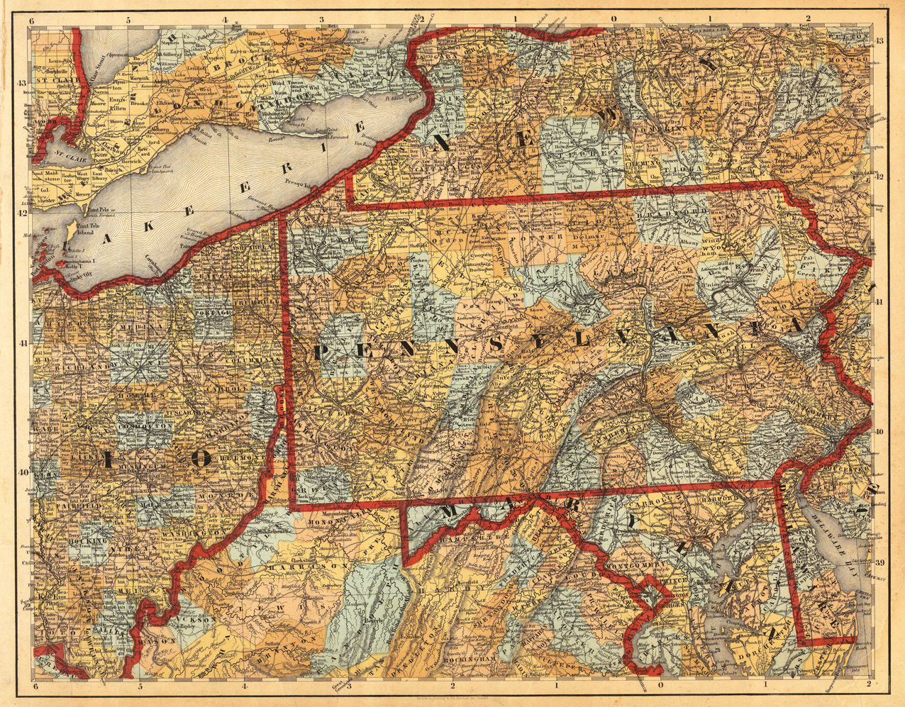
Lithograph, hand colored in outline and wash when published. This antique map shows prominent in its centre the state of Pennsylvania with its neighboring states New York, Ohio, Delaware, Maryland and Virginia. Inside the map are many place names, rivers, lakes, mountains, railroads, etc. Many counties are named and finely hand colored in wash. A detailed map of this part of the Eastern United States by the famous 19th century mapmaker and cartographer Calvin Smith. This is one sheet (map no 7) of Calvin Smith's famous map of North America. Here is the rare version in lithograph present, published in Cassel in Germany. A splendid detailed map, showing nicely Pennsylvania and adjacenting parts. The map is highly detailed colored in outline and wash by counties and states. An interesting collector's piece.
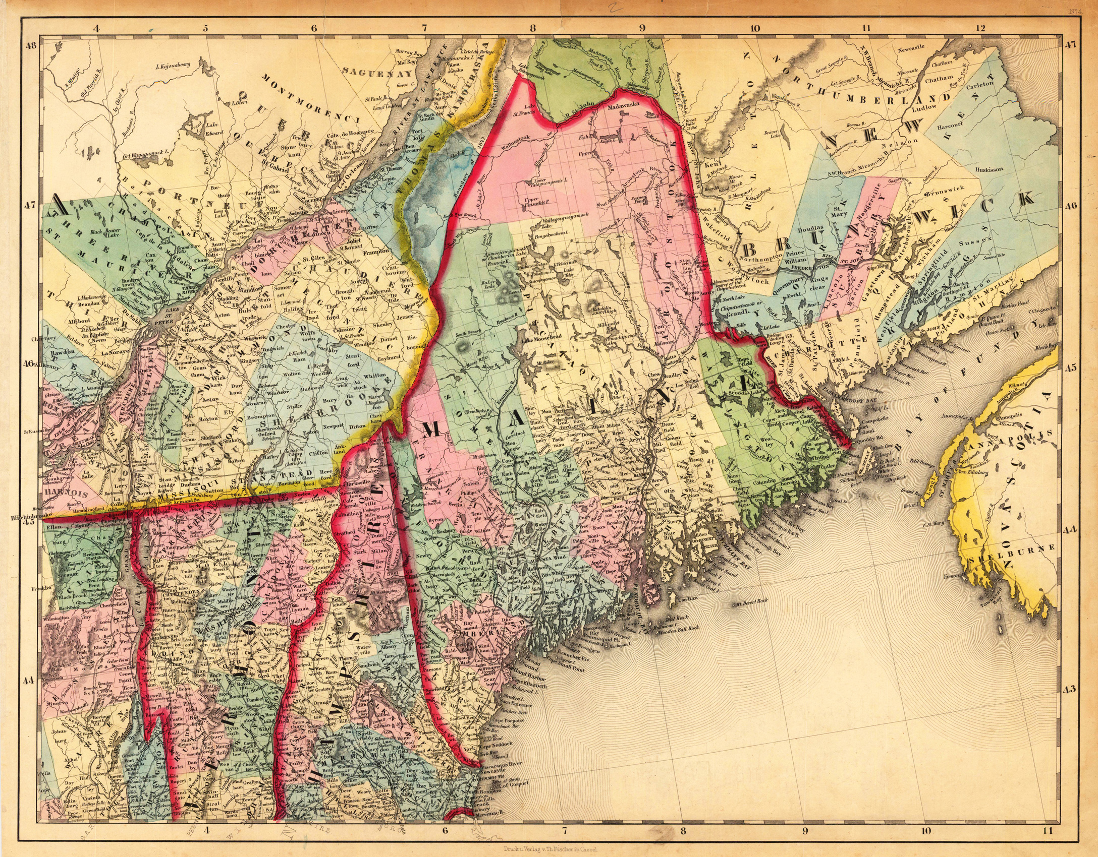
Lithograph, hand colored in outline and wash when published. This antique map shows prominent in its centre the state of Maine with its neighboring states Vermont, New Hampshire and New Brunswick. The map extends from Salisbury in the south towards New Brunswick and the neighboring Nova Scotia. Inside the map are many place names, rivers, lakes, mountains, railroads, etc. Many counties are named and finely hand colored in wash. A detailed map of this part of the Northeastern United States by the famous 19th century mapmaker and cartographer Calvin Smith. This is one sheet (map no 4) of Calvin Smith's famous map of North America. Here is the rare version in lithograph present, published in Cassel in Germany. A splendid detailed map, showing nicely Maine and adjacenting parts. The map is highly detailed colored in outline and wash by counties and states. An interesting collector's piece.
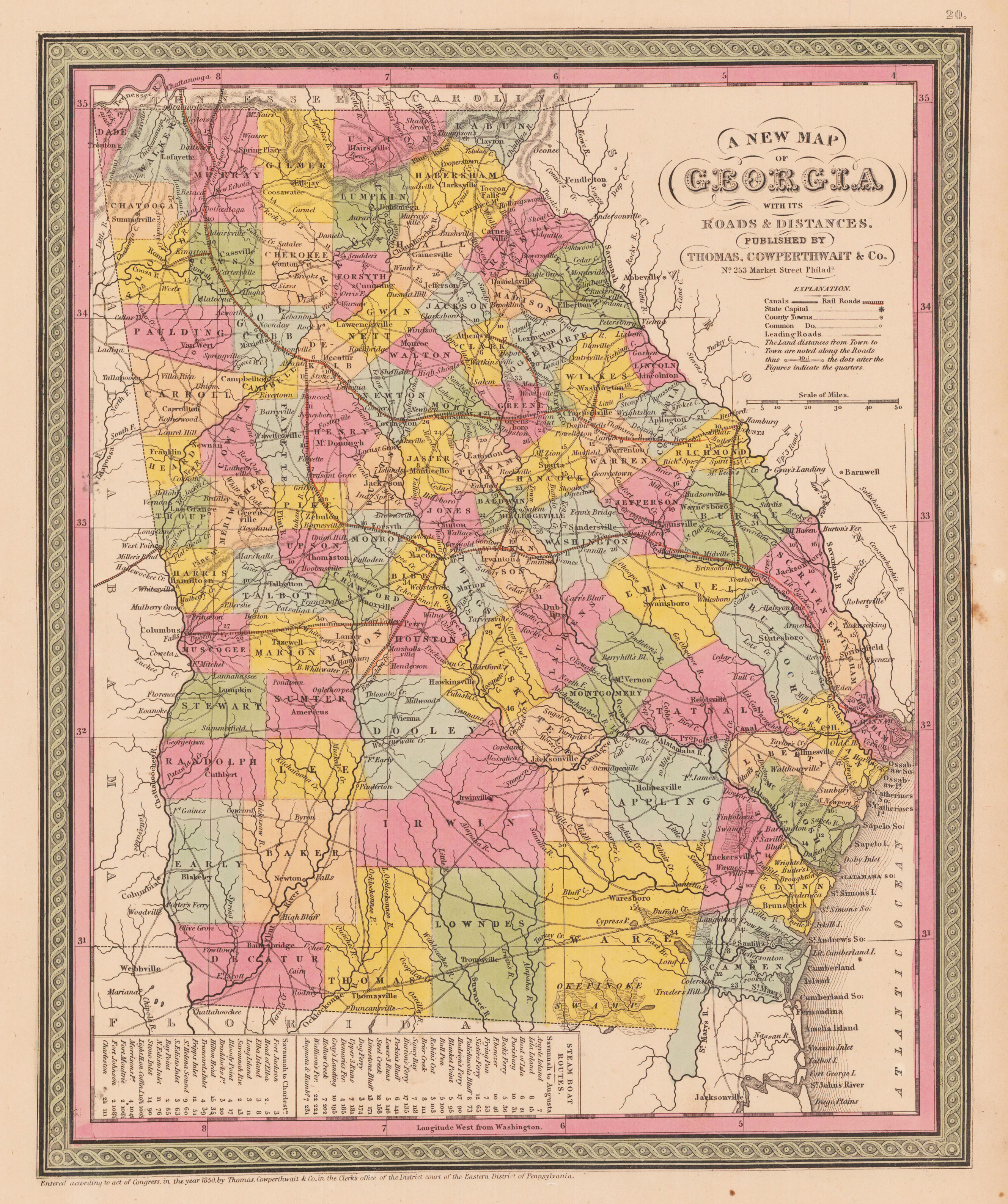
Steel engraving, hand colored in outline and wash. This map of Georgia centers our attention on the roads and railroads that crisscross the state. Political and topographical features are noted and color coded with elevation rendered by hachure. Steamboat routes and mileages are presented in tabular format in the lower left quadrant. The whole is engraved and colored in Mitchell's distinctive style with green border work and vivid pastels.
Lithograph, original hand colored in outline. Large and detailed map showing the Eastern Seaboard from Duxbury, CT. across Massachusetts, New Hampshire towards Columbia near Pleasant River in northern Maine. Inland the map extends towards the state of New York with Lake Ontario. Equipped with detailed information on the names of rivers and lakes, mountains, Forts and Indian tribes. The map was published in Phillippe Marie Vandermaelen's atlas of North America.
Lithograph, original color in wash when published. This antique map shows five towns (Annandale, Barrytown, Upper Red Hook, Madalin and Tivoli) from of boroughs of New York with their city centers, main streets. Certain buildings or possessions are marked.
Original copper engraving, handcolored in wash and outline, when published. A famous and decorative map of New England, showing the Eastcoast from South of the Chesapeake towards the St. Lawrence river in the North. The map was published in 1651 by J. Jansson for the first time. We also find examples of this map in Janssons' Seatatlas and the Atlas Constractus. This Dutch map is a detailed and informative map of the Dutch province of New Netherland and the surrounding region. 'It shows English settlements on the west end of Long Island (Greenwyck, Gravesand), along the shore of Long Island Sound (Stamford, Strotford, Nieuhaven and Milfort ... ' Tooley p. 283. The map was ornated with a decorative floral vignettes around the title cartouche and a small decorative dedication to Gualthero de Raet. As well Indian life, probably taken from the de Bry' s voyages, was used to ornate this map. The map here is present in its third state published by Schenk and Valk.
Copper engraving, hand colored. Decorative regional map, extending from the Mississippi Valley, from Illinois in the north to Florida and the Gulf Coast in the south. In the lower left corner is an inset which shows one of the first maps of Kansas City and the surounding.
Copper engraving, hand colored in outline and wash. Detailed map including Virginia, Georgia and the Carolinas, published shortly after the conclusion of the American Revolution. Rigobert Bonne (1727-1794) was a French cartographer of the late 18th century. He studied in Paris and practiced cartography. He became a skilled cartographer and hydrographer and became a royal hydrographer at the ,Depot de la Marine' in 1773. In 1780 he engraved and published the maps for Abbe Raynal's work ,Atlas de Toutes Les Parties Connues du Globe Terrestre'. He also published many charts for the ,Depot de la Marine', further he engraved the maps for the ,Atlas Encyclopedique' in 1788 together with Nicholas Desmarest.
Copper engraving, hand colored in outline and wash when published. Fine engraved map of the 'District of Columbia' showing a plan of the city of Washington. One of the earliest obtainable maps of the District of Columbia, which was published in an atlas. The map shows the plan of Washington, D.C. with the Potomac River and the nearby city of Alexandria with the adjacenting borders to Maryland and Virginia. The map is surrounded by descriptive text on the District of Columbia, providing information on the climate, the rivers, cities and its history. A nice and decorative plan & map of Washington, D.C. French edition of the 1822 in Philadelphia published map by Carey & Lea. The actual map, which is surrounded by text, has the size of approx. 10 1/2 x 10 inches.
Copper engraving, hand colored in outline and wash when published. Fine engraved map of the state of Rhode Island showing various rivers, trails, streets, villages and small place names. Rhode Island is divided up into its counties in original wash hand color. The map is surrounded by descriptive text on Rhode Island providing information on the climate, the rivers, cities and its history. A nice and decorative map of the state of Rhode Island. French edition of the 1822 in Philadelphia published map by Carey & Lea. The actual map, which is surrounded by text, has the size of approx. 21 x 8 1/4 inches.
Original antique lithograph, colored in outline and wash when published. This very detailed antique map shows the states Maryland, Delaware and Pennsylvania. The cartouche and an inset map of the district of Columbia is in the lower left corner. Some explanations and a mileage scale are on the left of the inset map.
Original lithograph, handcolored in outline and printed in colors. Large and detailed map showing the eastern part of the United States with its railroads and water streets. The map provides a huge amount of information (bays, canals, forts, gulfs, lakes, hills, Sierras, Indians, etc.), as well several inset maps (Boston, New York and Maine) and one inset map of the southern part of Florida.
Lithograph, original color in outline and wash. A highly interesting map of the eastern seaboard depicting the sea bed of the atlantic ocean. Three maps on one sheet: The east coast from Massachusetts to Florida, Long Island and the region between Florida and Cuba.
Lithograph, original color in outline and wash. A highly interesting map of the eastern seaboard depicting the sea bed of the atlantic ocean. Three maps on one sheet: The east coast from Massachusetts to Florida, Long Island and the region between Florida and Cuba.
Steel engraving, original color in outline when published. This antique map shows the East Coast States New York, Pennsylvania, Maryland, New Jersey, Delaware and Virginia. The map is very detailed engraved with many place names, rivers, streets, etc. Inside the map are six inset maps which shows the surroundings of capitols or remarkable places of these states. A detailed engraved map by the famous German map maker Meyer Joseph. The map is based on Tanner's work in the early 1840s.
Original copper engraving, uncolored. The map is from Schrambl's Allgemeiner Grosser Atlas, begun in 1786. The map image shows from Labrador in the north to West Florida in the south and from California in the west to Newfoundland in the east. In the upper left corner is an inset map of Baffin and Hudson Bay: "Specialkarte von der Baffin und Hudsons Bai." Shows boundaries, forts, roads, mines, and Indian villages and tribal territory.
Lithograph, original color in outline and wash. Detailed map, colored by counties and showing townships, towns, villages, post offices, canals, roads, railroads (projected and completed), towns, etc. An inset in the upper right corner shows the environment of Boston. A highly detailed map.
Lithograph, original color in outline and wash. Detailed map, colored by counties and showing townships, towns, villages, post offices, canals, roads, railroads (projected and completed), towns, etc. An inset in the lower right corner shows the Eastern part of Maine. A highly detailed map.
Lithograph, original color in outline and wash. This very detailed antique map shows the states Maryland, Delaware and Pennsylvania. The cartouche and an inset map of the district of Columbia is in the lower left corner. Some explanations and a mileage scale are on the left of the inset map.
Lithograph, original color in outline and wash. This antique map shows the states New Hampshire and Vermont. The map is very detailed engraved with many place names, rivers, streets etc. A decorative large scale map of New Hampshire & Vermont, decorated with an ornated border around the map.
Original antique lithograph, published uncolored. Published in Amérique Septentrionale. Printed by Henry Gaugain, Paris. An outstanding view from Milbert's Itinéraire pittoresque du fleuve Hudson et des parties latérales de l'Amérique du Nord. Milbert arrived in the United States in 1815, with the backing of the Museum of Natural History in Paris, with instructions to explore, record and collect as much information about the topography, social history, and flora and fauna of the north east of the country as possible. The task took him seven years, and in addition to the 8,000 natural history specimens he sent back to Franc, he made a series of highly significant sketches of the areas through which he travelled. The present image, an important early example of the use of lithography for topographical prints, is part of this eye-witness record of life in America in the early 19th century which forms the most comprehensive and accurate depiction of the country at the time. As 'an artist, Milbert loved to paint American landscapes, particularly those that showed the Hudson, "King of Rivers", flowing majestically through the mountains… the pictures of what he saw, as of the time he drew them, constitute a unique and valuable record' (Sherman, A French Explorer in the Hudson Valley).
Lithograph, original hand colored in outline and wash. A very nice detailed map of the state of Maine with many small place names, rivers, ect. At the bottom we find the explanation of the map with a small mileage scale.
Steel engraving, uncolored as published. This antique map shows the states of Pennsylvania and New Jersey in the United States. Fine engraved map of Pennsylvania and New Jersey, showing the states divided up into its counties. The map is very detailed engraved with many place names, rivers, lakes, mountains, etc. In the upper left corner we see a ground plan of the city of Philadelphia with the Delaware River. A detailed engraved map by the famous German map maker Meyer Joseph. The map is based on Tanner's work in the early 1840s.