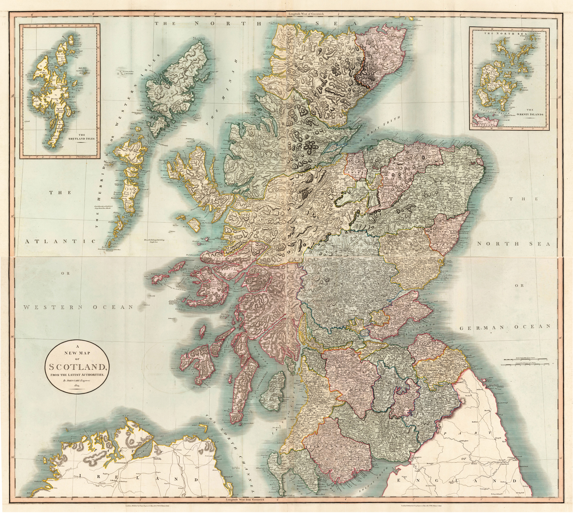
Copper engraving, handcolored in outline and wash when published. Large and very detailed map of Scotland divided up into its counties. In the upper corners two large inset maps of the Shetland Isles and the Orkney Islands. The map with much information on cities, smaller place names, castles, rivers, lakes, mountains, hills, roads (with distances), etc. The engraved borders of the counties are colored in outline. A fine copy on two double folio atlas sheets, as published.
Copper engraving, uncolored. Published in Allain M. Mallet's description of the world. This map shows us the the Kindom of Scotland. Inside the map are many names, rivers, mountains, etc.
Steel engraving, handcolored in outline and wash when published. Detailed map of Scotland divided up into its counties. In the upper right corner with a vignette city view of Edinburgh. The map with many information on place names, castles, rivers, lakes, mountains, railroads, etc. The borders of the counties are shown in outline colors. Engraved by L. Smith.
Original antique large woodcout after an print by Halman. This impressive sheet shows Edinburgh from the bird's eye view. The grid pattern of New Town appears in the foreground. The Castle is on the hill centre right, and the Royal Mile can be traced leading down from it to the Holyrood Palace. The hill at the top left is Arthur's Seat. Thomas Sulman was a student and later an engraver for Dante Gabriel Rossetti. He became a specialist in using hot air balloons to produce birds eye views of cities including London, Oxford, Edinburgh, Glasgow and New York.
Copper engraving, hand colored in outline and wash. Decorative antique map of the British Isles showing Scotland. This highly decorative rare map of the late 17th century is equipped with a large allegoric title cartouche in the upper left corner. At the upper right side a small mileage scale with coat of arms held by angels. With many engraved place names and details, the political borders shown in outline and wash color of the period as published.
Copper engraving, hand colored in outline and wash. Decorative antique map of the British Isles showing Scotland. This highly decorative rare map of the late 17th century is equipped with a large allegoric title cartouche in the upper left corner. At the upper right side a small mileage scale with coat of arms held by angels. With many engraved place names and details, the political borders shown in outline and wash color of the period as published.
Copper engraving, in contemporary original color in outline. Published in Zatta's "Atlante Novissimo". Decorative map by the famous late 18th century north-italian cartographer Antonio Zatta. With many names of villages, as well engraved mountains and rivers are showns. The handcolored engraved title cartouche ornated with a landscape. A small milage scale.
Copper engraving, in contemporary original color in outline. Published in Zatta's "Atlante Novissimo". Decorative map by the famous late 18th century north-italian cartographer Antonio Zatta. With many names of villages, as well engraved mountains and rivers are showns. The handcolored engraved title cartouche ornated with a landscape. A small milage scale.
Copper engraving, hand colored in outline when published. The decorative antique map showing Scotland, the Isles de L´Quest and the Isles Orcades. The title is in the upper left corner and three different mileage scales (German, France and Ecosse) in the right corner.
Steelengraving, handcolored in outline when published. The detailled map of Scotland is providing a lot of information on place names and rivers. As well shiproutes from Scotish harbours into the Atlantic Ocean and North Sea are engraved. The map is equipped with a milage scale in various languages.
Copper engraving, uncolored. Published in Allain M. Mallet's description of the world. This antique map shows us Scotland. Inside the map are many place names, rivers, mountains, ships. Also we see the neighbouring lands which are Irland, ...??
Steel engraving, hand colored in outline, when published. Small and decorative map of Scotland, showing many place names, rivers, mountains, streets and railroads. Ornated with two inset maps: Orkney islands - Shetland islands.
Steel engraving, hand colored in outline, when published. Small and decorative map of Scotland, showing many place names, rivers, mountains, streets and railroads. Ornated with two inset maps: Orkney islands - Shetland islands.
Copper engraving, uncolored as published. A fine copy in a dark impression, full margins as published. This is the first so-called Cloppenburgh editions which was a competive edition with new engraved maps in a larger format. Most of the maps were engraved by Pieter van den Keere. The Cloppenburgh edition was continued for a couple of years but seems to have been suppressed after 1636 ... . This is another Cloppenburgh edition, now with Latin text. The maps from the Appendix have been incorporated. The title-page is followed by a dedication to Prince Frederik Hendrik, dated 1632 and signed by Johannes Cloppenburgh. (Koeman Atlantes Neerlandici).
Copper engraving, uncolored as published. A fine copy in a dark impression, full margins as published. This is the first so-called Cloppenburgh editions which was a competive edition with new engraved maps in a larger format. Most of the maps were engraved by Pieter van den Keere. The Cloppenburgh edition was continued for a couple of years but seems to have been suppressed after 1636 ... . This is another Cloppenburgh edition, now with Latin text. The maps from the Appendix have been incorporated. The title-page is followed by a dedication to Prince Frederik Hendrik, dated 1632 and signed by Johannes Cloppenburgh. (Koeman Atlantes Neerlandici).
Original steel engraving, original color. Steel engraving, hand colored in outline and wash. Decorative antique map Scotland with some beautiful vignettes of scottish traditions and landmarks. Detailed map with many place names, rivers, mountains, etc. John Tallis (7 November 1817 – 3 June 1876) was an English cartographic publisher. His company, John Tallis & Company, published views, maps and atlases in London from roughly 1838 to 1851. Tallis set up as a publisher with Frederick Tallis in Cripplegate in 1842; the business moved to Smithfield in 1846, and was dissolved in 1849. From 1851 to 1854 Tallis operated as John Tallis & Company. He started the Illustrated News of the World which issued engraved portraits as supplements in a series entitled 'National Portrait Gallery of eminent personages' in 1858, selling it for £1,370 in 1861; it folded in 1863. The series was subsequently republished in a number of separate volumes. He lived in New Cross, South East London. His house on New Cross Road is listed as a Building of Special Architectural or Historic Interest, grade II. It has a blue plaque on the wall to signal the event. (Wikipedia)
Copper engraving, hand colored in outline when published. A detailed and interesting map by the German mapmaker Carl Ferdinand Weiland depicting Scotland and the Shetland Island with an inset map. Engraved title and explanations for the map on cities, towns, villages, castles, fortresses, lighthouses, streets, channels, etc.
Steel engraving, hand colored in outline and wash when published. Engraved by Hamm, P.E. This fine small engraved old map shows Scotland. This rare antique original map was published by Carey & Lea in Philadelphia in a small pocket atlas. Detailed engraved with place names, rivers and mountain chains.