Original antique copper engraving, hand colored in outline and wash. Engraved after a sketch by J. G. Schreiber published at Homanns Heirs in Nürnberg. Das Kartenbild zeigt den Bereich von Borna im Osten bis Camburg im Westen, im Norden von Freiburg bis Gerau im Süden. In der linken unteren Ecke ist eine große allegorische Titelkartusche graviert. Eine Erklärung der Zeichen über die Größe der Städte und Dörfer, Straßen und Brücken ist in der oberen rechten Ecke angebracht. The map shows the area from Borna in the east to Camburg in the west, in the north from Freiburg to Gerau in the south. A large allegorical title cartouche is engraved in the lower left corner. An explanation of the signs about the size of towns and villages, streets and bridges is in the upper right corner. Johann Baptist Homann (20 March 1664 – 1 July 1724) was a German geographer and cartographer, who also made maps of the Americas. Homann was born in Oberkammlach near Kammlach in the Electorate of Bavaria. Although educated at a Jesuit school, and preparing for an ecclesiastical career, he eventually converted to Protestantism and from 1687 worked as a civil law notary in Nuremberg. He soon turned to engraving and cartography; in 1702 he founded his own publishing house. Homann acquired renown as a leading German cartographer, and in 1715 was appointed Imperial Geographer by Emperor Charles VI. Giving such privileges to individuals was an added right that the Holy Roman Emperor enjoyed. In the same year he was also named a member of the Prussian Academy of Sciences in Berlin. Of particular significance to cartography were the imperial printing privileges (Latin: privilegia impressoria). These protected for a time the authors in all scientific fields such as printers, copper engravers, map makers and publishers. They were also very important as a recommendation for potential customers. In 1716 Homann published his masterpiece Grosser Atlas ueber die ganze Welt (Grand Atlas of all the World). Numerous maps were drawn up in cooperation with the engraver Christoph Weigel the Elder, who also published Siebmachers Wappenbuch. Homann died in Nuremberg in 1724. He was succeeded by his son Johann Christoph (1703-1730). The company carried on upon his death as Homann heirs company, managed by Johann Michael Franz and Johann Georg Ebersberger. After subsequent changes in management the company folded in 1852.[1] The company was known as "Homann Erben", "Homanniani Heredes", or "Heritiers de Homann" abroad. (Wikipedia)
Original antique copper engraving, uncolored as published. Decorative engraving of the city hall of Wittenberg. This fine engraving was published in Gabriel Bodenehr's famous serious "Europeans Macht und Pracht", a series of engravings depicting city views, plans, fortresses and castles in Europe. Many plates often are showing fortifications in Hungary and Southeast Europe, Spain, Belgium, Austria and Germany. Gabriel Bodenehr was during this period a successful publisher for maps and prints in Augsburg in Southern Germany. Gabriel Bodenehr the Elder (1664-1758 or 1673-1765) was a German map maker and member of a famous engraver and publisher family of Augsburg. His main work was "Atlas Curieux" first published 1704. He was the son of Johann Georg Bodenehr (1631-1703). Gabriel's son was Gabriel Bodenehr the Younger (1705–1792).
Original antique copper engraving, uncolored as published. This fine copper engraving shows the cathedrale of Magdeburg in Eastern Germany and was published in Gabriel Bodenehr's famous serious "Europeans Macht und Pracht", a series of engravings depicting city views, plans, fortresses and castles in Europe. Many plates often are showing fortifications in Hungary and Southeast Europe, Spain, Belgium, Austria and Germany. Gabriel Bodenehr was during this period a successful publisher for maps and prints in Augsburg in Southern Germany. Gabriel Bodenehr the Elder (1664-1758 or 1673-1765) was a German map maker and member of a famous engraver and publisher family of Augsburg. His main work was "Atlas Curieux" first published 1704. He was the son of Johann Georg Bodenehr (1631-1703). Gabriel's son was Gabriel Bodenehr the Younger (1705–1792).
Original antiker Kupferstich in zeitgenössischem Handkolorit. Dieses dekorative Blatt zeigt 2 Ansichten übereinander. Halberstadt (oben), am Fuße des Harzes, von Süden aus gesehen. Die drei Kirchen, die die Skyline dominieren, sind (von links) die romanische Liebfrauen-Pierbasilika mit ihren vier Türmen, die gotische Kathedrale St. Stephen mit zwei Türmen und die dreischiffige gotische Kirche St. Martin mit ihrem höheren Südturm. Neben der Stadtmauer im linken Vordergrund steht die gotische Dreischiffskirche St. Andreas, welche heute das Franziskanerkloster Halberstadt beheimatet. Darunter die Ansicht von Quedlinburg. Der Blick von Südosten zeigt links den Burgberg mit der dreischiffigen romanischen Kathedrale St. Servatius, in der die Gräber von König Heinrich I. und seiner Frau St. Mathilde untergebracht sind. Ein markantes Merkmal der Stadt selbst sind die vier parallel ausgerichteten Kirchen (von links): St. Blasius, die Marktkirche St. Benedikt, die spätgotische Kirche St. Ägidii mit ihren massiven Türmen und die Kirche St. Nikolaus mit ihren 72 Meter hohen Zwillingstürmen. Quedlinberg gewann ab dem 10. Jahrhundert an Bedeutung, als es eine kaiserliche Pfalz wurde und die Enkeltochter von Heinrich I., Mathilda, von Otto I. als erste Äbtissin des Klosters bestätigt wurde. Georg Braun (auch Brunus, Bruin; 1541 - 10. März 1622) war ein Topogeograph. Von 1572 bis 1617 redigierte er das Civitates orbis terrarum, das 546 Perspektiven, Vogelperspektiven und Karten von Städten aus aller Welt enthält. Braun wurde in Köln geboren und starb dort 1622 als Achtzigjähriger. Sein Hauptberuf war katholischer Geistlicher. Er verbrachte jedoch 37 Jahre als Kanoniker und Dekan in der Kirche St. Maria ad Gradus in Köln. Sein sechsbändiges Werk wurde von Sebastian Münsters Cosmographia inspiriert. In Form und Anordnung ähnelt es dem Theatrum orbis terrarum von Abraham Ortelius von 1570, da Ortelius an einem ergänzenden Begleiter für das Theatrum interessiert war. Frans Hogenberg (1535–1590) war ein flämischer und deutscher Maler, Graveur und Kartenmacher. Hogenberg wurde in Mechelen in Flandern als Sohn von Nicolaas Hogenberg geboren. 1568 wurde er vom Herzog von Alva aus Antwerpen verbannt und reiste nach London, wo er einige Jahre blieb, bevor er nach Köln auswanderte. Er ist bekannt für Porträts und topografische Ansichten sowie historische Allegorien. Er produzierte auch Szenen zeitgenössischer historischer Ereignisse. Hogenberg starb in Köln. (Wikipedia)
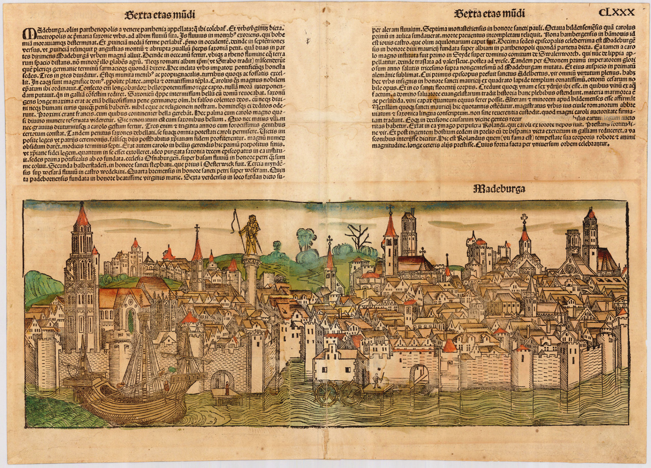
Original woodcut from the famous Nurnberg Chronicle, printed in Nürnberg in December 1493. This plate was exactly published and printed in December 1493 in Nurnberg at Anton Koberger. Decorative hand colored view across the river Elbe towards the medieval town Magdeburg in Sachsen Anhalt.
Original antique copper engraving, uncolored. Published in A. Ortelius Theatrum Orbis Terrarum, french edition by Moretus. The county of Mansfeld is shown on the map by Tilmann Stella. Detailed map with many locations, rivers, forests, etc. Nice uncolored copy. The title cartouche is engraved in the upper right corner and a mileage scale in the lower margin. Ortelius was born on 14 April 1527 in the city of Antwerp, which was then in the Habsburg Netherlands (modern-day Belgium). The Orthellius family were originally from Augsburg, a Free imperial city of the Holy Roman Empire. In 1535, the family had fallen under suspicion of Protestantism. Following the death of Ortelius's father, his uncle Jacobus van Meteren returned from religious exile in England to take care of Ortelius. Abraham remained close to his cousin Emanuel van Meteren, who would later move to London. In 1575 he was appointed geographer to the king of Spain, Philip II, on the recommendation of Arias Montanus, who vouched for his orthodoxy. He travelled extensively in Europe and is specifically known to have traveled throughout the Seventeen Provinces; in southern, western, northern, and eastern Germany (e.g., 1560, 1575–1576); France (1559–1560); England and Ireland (1576); and Italy (1578, and perhaps twice or thrice between 1550 and 1558). Beginning as a map-engraver, in 1547 he entered the Antwerp Guild of Saint Luke as an illuminator of maps. He supplemented his income trading in books, prints, and maps, and his journeys included yearly visits to the Frankfurt book and print fair, where he met Gerardus Mercator in 1554. In 1560, however, when travelling with Mercator to Trier, Lorraine, and Poitiers, he seems to have been attracted, largely by Mercator's influence, towards the career of a scientific geographer. (Wikipedia)
Original antique copper engraving, uncolored. Published in A. Ortelius Theatrum Orbis Terrarum, Italian text edition. The county of Mansfeld is shown on the map by Tilmann Stella. Detailed map with many locations, rivers, forests, etc. Nice uncolored copy. The title cartouche is engraved in the upper right corner and a mileage scale in the lower margin. Ortelius was born on 14 April 1527 in the city of Antwerp, which was then in the Habsburg Netherlands (modern-day Belgium). The Orthellius family were originally from Augsburg, a Free imperial city of the Holy Roman Empire. In 1535, the family had fallen under suspicion of Protestantism. Following the death of Ortelius's father, his uncle Jacobus van Meteren returned from religious exile in England to take care of Ortelius. Abraham remained close to his cousin Emanuel van Meteren, who would later moved to London. In 1575 he was appointed geographer to the king of Spain, Philip II, on the recommendation of Arias Montanus, who vouched for his orthodoxy. He travelled extensively in Europe and is specifically known to have traveled throughout the Seventeen Provinces; in southern, western, northern, and eastern Germany (e.g., 1560, 1575–1576); France (1559–1560); England and Ireland (1576); and Italy (1578, and perhaps twice or thrice between 1550 and 1558). Beginning as a map-engraver, in 1547 he entered the Antwerp Guild of Saint Luke as an illuminator of maps. He supplemented his income trading in books, prints, and maps, and his journeys included yearly visits to the Frankfurt book and print fair, where he met Gerardus Mercator in 1554. In 1560, however, when travelling with Mercator to Trier, Lorraine, and Poitiers, he seems to have been attracted, largely by Mercator's influence, towards the career of a scientific geographer. (Wikipedia)
Original antique copper engraving, uncolored as published. Decorative panoramic view of the city Naumburg in Saxony-Anhalt. This fine engraving was published in Gabriel Bodenehr's famous serious "Europeans Macht und Pracht", a series of engravings depicting city views, plans, fortresses and castles in Europe. Many plates often are showing fortifications in Hungary and Southeast Europe, Spain, Belgium, Austria and Germany. Gabriel Bodenehr was during this period a successful publisher for maps and prints in Augsburg in Southern Germany. Gabriel Bodenehr the Elder (1664-1758 or 1673-1765) was a German map maker and member of a famous engraver and publisher family of Augsburg. His main work was "Atlas Curieux" first published 1704. He was the son of Johann Georg Bodenehr (1631-1703). Gabriel's son was Gabriel Bodenehr the Younger (1705–1792).
Original antiker Kupferstich, erschienen um 1710 in,Beckmann, Johann Christoph - Historie des Fürstenthums Anhalt. Von dessen Alten Einwohnern und einigen annoch vorhandene Alten Monumenthen...' Oben in der Mitte innerhalb der Darstellung betitelt. Die Ansicht zeigt Schloss Coswig aus der halben Vogelschau. Im Vordergrund auf der linken Seite ein Lastenboot auf der Elbe und an Land eingraviert die "Perspectivische Maasse". Beckmann, Johann Christoph - (1641 Zerbst - 1717 Frankfurt/Oder) deutscher Universitätsprofessor, Bibliothekar und Chronist. Wirkte bis zu seinem Lebensende als Professor für Griechisch, Geschichte und Theologie an der Universität Frankfurt/Oder. Er publizierte zahlreiche Werke in unterschiedlichen Fachgebieten. Besonders bedeutsam war sein 1676 erschienener alphabetischer Katalog der Universitätsbibliothek Frankfurt und seine Historie des Fürstentums Anhalt. Eine erste Erwähnung einer Burg in Coswig datiert auf das Jahr 1187. Das Schloss selbst wurde 1342 ersterwähnt, als Leibgeding der Fürstin Agnes von Anhalt. Die Fürsten von Anhalt hatten ihren Sitz ab 1212 in Coswig. Während der Eroberung durch die Spanier 1547 wurde das Schloss durch einen Brand zerstört und von 1555 bis 1560 neu errichtet. Das Vorgängerschloss wurde ab 1562 wiederholt als Witwensitz genutzt. Das Schloss wurde von 1622 bis 1623 ausgebaut, ebenso von 1667 bis 1677. Der Südflügel wurde unter Cornelis Ryckwaert von 1676 bis 1679 erneuert und 1698 bis auf die Terrasse abgetragen. Unter Johann Christoph Schütze erfolgten weitere Umbauten von 1725 bis 1740, dabei wurde das Innere des Gebäudes vollkommen verändert. Nach dem Tod von Friedrich August Fürst von Anhalt-Zerbst im Jahr 1793 übernahm seine Gattin Friederike Auguste Sophie von Anhalt-Zerbst, eine Prinzessin aus dem Hause Anhalt-Bernburg die Regierungsgeschäfte ihres Mannes. Da das Gebäude in seiner damaligen, entsprach ihr nicht als Witwensitz und ließ es zum heutigen Schlossgebäude ausbauen. Zusammen mit ihrer Schwester Christine von Schwarzburg-Sondershausen verbrachte sie, nach ihrer Abdankung 1806, den Rest ihres Lebens bis zu ihrem Tod im Jahr 1827 auf dem Schloss. Mit ihr endete die glanzvolle Zeit des Schlosses und Coswigs. Während des Deutschen Kriegs von 1866 war im Schloss ein Lazarett untergebracht und von 1870 bis 1871 diente es als Kriegsgefangenenlager. Ab 1873 diente es als Zuchthaus für 300 Insassen, dafür wurde der Südflügel um zwei Stockwerke erweitert. Während der Zeit des Dritten Reiches waren in Zellen bis zu 900 politische Gefangene und während der DDR-Zeit bis 1957 war dort die Strafanstalt Coswig untergebracht. 1958 begannen Restaurierungsarbeiten, in deren Anschluss das Gebäude ab 1961 als Außenstelle des Landes- und Staatsarchives bis zur Deutschen Wiedervereinigung im Jahr 1989 genutzt wurde. Danach nutzte das Bundesarchiv das Gebäude bis 1998 weiter. Von 1998 bis 2006 stand das Gebäude leer und gelangte dann in den Besitz der Italienerin Dr. Magnolia Albertazzi aus Mailand. Geplant ist eine Nutzung des Schlosses als Zentrum für transnationale Kooperation und Austausch auf dem Gebiet der Kultur. Die Gefängnisetagen wurden 2008 abgerissen und der Südflügel in seinen historischen Zustand zurück versetzt. Seit 2014 finden im Gebäude Konzerte statt. (Wikipedia)
Original antique copper engraving, hand colored in outline and wash when published. The plate was first published in the townbooks ,Civitates Orbis Terrarum' by Braun & Hogenberg. The plates were later aquired by J. Janssonius and were published in his townbooks 1657 in Amsterdam. Johannes Janssonius (1588, Arnhem – buried July 11, 1664, Amsterdam) (born Jan Janszoon, in English also Jan Jansson) was a Dutch cartographer and publisher who lived and worked in Amsterdam in the 17th century. Janssonius was born in Arnhem, the son of Jan Janszoon the Elder,[1] a publisher and bookseller. In 1612 he married Elisabeth de Hondt, the daughter of Jodocus Hondius. He produced his first maps in 1616 of France and Italy. In 1623 Janssonius owned a bookstore in Frankfurt am Main, later also in Danzig, Stockholm, Copenhagen, Berlin, Königsberg, Geneva and Lyon. Elisabeth Hondius died in 1627 and he remarried Elisabeth Carlier in 1629. In the 1630s he formed a partnership with his brother in law Henricus Hondius, and together they published atlases as Mercator/Hondius/Janssonius. Under the leadership of Janssonius the Hondius Atlas was steadily enlarged. Renamed Atlas Novus, it had three volumes in 1638, one fully dedicated to Italy. In 1646, a fourth volume came out with "English County Maps", a year after a similar issue by Joan Blaeu. Janssonius' maps are similar to those of Blaeu, and he is often accused of copying from his rival, but many of his maps predate those of Blaeu and/or covered different regions. By 1660, at which point the atlas bore the appropriate name "Atlas Major", there were 11 volumes, containing the work of about a hundred credited authors and engravers. It included a description of "most of the cities of the world" (Townatlas), of the waterworld (Atlas Maritimus in 33 maps), and of the Ancient World (60 maps). The eleventh volume was the Atlas of the Heavens by Andreas Cellarius. Editions were printed in Dutch, Latin, French, and a few times in German. After Janssonius's death, the publishing company was continued by his son-in law, Johannes van Waesbergen. The London bookseller Moses Pitt attempted publication of the Atlas Major in English, but ran out of resources after the fourth volume in 1683. (Wikipedia)
Copper engraving, hand colored in outline when published. Decorative view of the church if St. Peter in Magdeburg in Eastern Germany. This fine engraving was published in Gabriel Bodenehr's famous serious "Europeans Macht und Pracht", a series of engravings depicting city views, plans, fortresses and castles in Europe. Many plates often are showing fortifications in Hungary and Southeast Europe, Spain, Belgium, Austria and Germany. Gabriel Bodenehr was during this period a successful publisher for maps and prints in Augsburg in Southern Germany. Gabriel Bodenehr the Elder (1664-1758 or 1673-1765) was a German map maker and member of a famous engraver and publisher family of Augsburg. His main work was "Atlas Curieux" first published 1704. He was the son of Johann Georg Bodenehr (1631-1703). Gabriel's son was Gabriel Bodenehr the Younger (1705–1792).
Copper engraving, hand colored in outline when published. This fine engraving shows the panoramic view of Meissen and was published in Gabriel Bodenehr's famous serious "Europeans Macht und Pracht", a series of engravings depicting city views, plans, fortresses and castles in Europe. Many plates often are showing fortifications in Hungary and Southeast Europe, Spain, Belgium, Austria and Germany. Gabriel Bodenehr was during this period a successful publisher for maps and prints in Augsburg in Southern Germany. Gabriel Bodenehr the Elder (1664-1758 or 1673-1765) was a German map maker and member of a famous engraver and publisher family of Augsburg. His main work was "Atlas Curieux" first published 1704. He was the son of Johann Georg Bodenehr (1631-1703). Gabriel's son was Gabriel Bodenehr the Younger (1705–1792).
Copper engraving, hand colored in outline when published. This fine engraving shows the panoramic view of Wittenberg and was published in Gabriel Bodenehr's famous serious "Europeans Macht und Pracht", a series of engravings depicting city views, plans, fortresses and castles in Europe. Many plates often are showing fortifications in Hungary and Southeast Europe, Spain, Belgium, Austria and Germany. Gabriel Bodenehr was during this period a successful publisher for maps and prints in Augsburg in Southern Germany. Gabriel Bodenehr the Elder (1664-1758 or 1673-1765) was a German map maker and member of a famous engraver and publisher family of Augsburg. His main work was "Atlas Curieux" first published 1704. He was the son of Johann Georg Bodenehr (1631-1703). Gabriel's son was Gabriel Bodenehr the Younger (1705–1792).