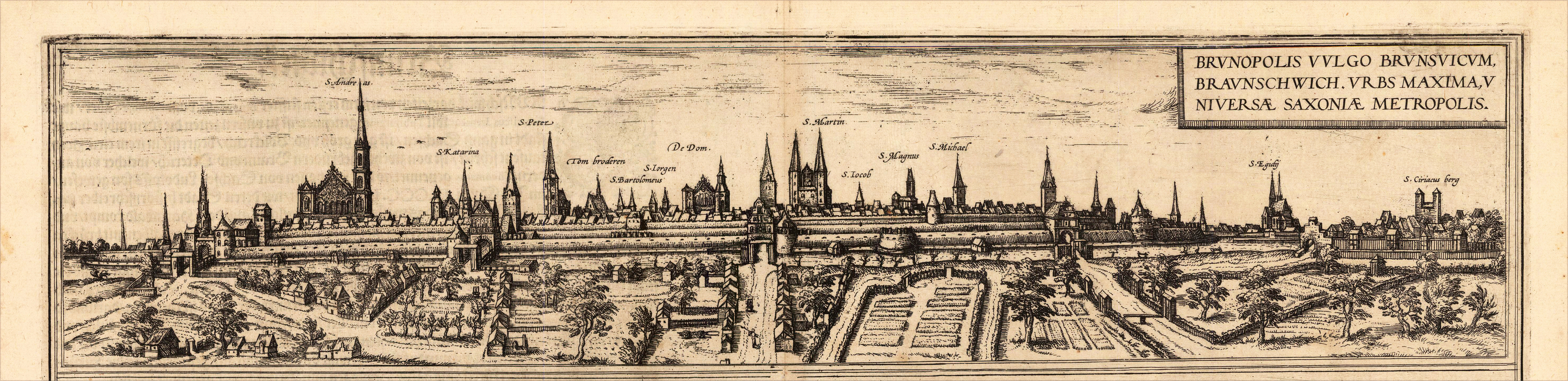
Original copper-engraving, handcolored in wash, published 1617 in the townbook 'Civitates Orbis Terrarum' by Braun and Hogenberg. The entire series of the 'Civitates Orbis Terrarum' comprised six volumes and was published and printed from 1572 towards 1619. Dargestellt wird die Stadt Braunschweig in Niedersachsen als Panoramaansicht mit der alten Stadtmauer und Ansiedlungen mit Gärten im Vordergrund. The city of Braunschweig in Lower Saxony is shown as a panoramic view with the old city wall and settlements with gardens in the foreground. Georg Braun (also Brunus, Bruin; 1541 – 10 March 1622) was a topo-geographer. From 1572 to 1617 he edited the Civitates orbis terrarum, which contains 546 prospects, bird's-eye views and maps of cities from all around the world. He was the principal editor of the work, he acquired the tables, hired the artists, and wrote the texts. He died as an octogenarian in 1622, as the only survivor of the original team to witness the publication of volume VI in 1617. Braun was born and died in Cologne. His principal profession was as a Catholic cleric. However, he spent thirty-seven years as canon and dean at the church, St. Maria ad Gradus, in Cologne. His six-volume work was inspired by Sebastian Münster's Cosmographia. In form and layout it resembles the 1570 Theatrum orbis terrarum by Abraham Ortelius, as Ortelius was interested in a complementary companion for the Theatrum. The Braun publication set new standards in cartography for over 100 years. Frans Hogenberg (1535–1590, from Mechelen) created the tables for volumes I through IV, and Simon van den Neuwel created those for volumes V and VI. Other contributors were Joris Hoefnagel, Jacob Hoefnagel, cartographer Daniel Freese, and Heinrich Rantzau. Works by Jacob van Deventer, Sebastian Münster, and Johannes Stumpf were also used. Primarily European cities are depicted in the publication; however, Cairo Casablanca and Mexico City as well as Cuzco on one sheet are also included in volume I, whereas Tunis is featured in volume II. Frans Hogenberg (1535–1590) was a Flemish and German painter, engraver, and mapmaker. Hogenberg was born in Mechelen in Flanders as the son of Nicolaas Hogenberg. In 1568 he was banned from Antwerp by the Duke of Alva and travelled to London, where he stayed a few years before emigrating to Cologne. He is known for portraits and topographical views as well as historical allegories. He also produced scenes of contemporary historical events. Hogenberg died in Cologne. (Wikipedia)
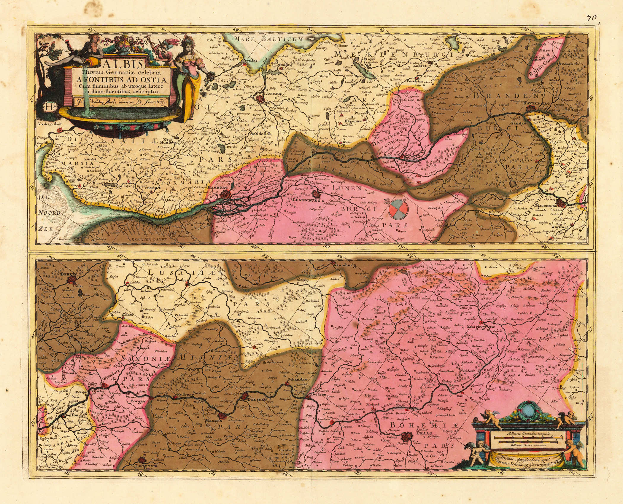
Kupferstichkarte, in zeitgenössischem Grenz- u. Flächenkolorit. Links oben allegorische ausgemalte Titelkartusche, unten rechts Meilenzeiger mit Verlegerangaben von Putten verziert. Dargestellt wird in 2 Kartenteilen (je 19,5 x 49cm) der Lauf der Elbe. Gezeigt wird der Verlauf der Elbe vom Quellgebiet in Böhmen bis zur Mündung in die Nordsee. Detaillierte Karte mit vielen Ortsangaben in zeitgenössischem prächtigem Altkolorit.
Original antique copper engraving, hand colored in outline when published. Kupferstichkarte erschienen in Blaeu's Theatrum. Links unten große alleg. Rollwerkskartusche mit Meilenzeiger u. Wappen. Zeigt detailliert mit vielen Ortsangaben das Herzogtum Braunschweig. Im Norden angrenzend das Herzogtum Lüneburg, im Süden das Eichsfeldt. Im Westen bis Minden u. östl. bis Quedlinburg. Kartenbild mit 6 gestochenen Wappenschildern verziert. Dekorative Karte mit vielen Ortsangaben, die Berge des Harzgebirges schön herausgearbeitet. Original map published in Blaeu's Theatrum. Large alleg. Rollwerk cartouche with miles pointer u. Coat of arms. Shows the Duchy of Braunschweig in detail with many locations. In the north the Duchy of Lüneburg, in the south the Eichsfeldt. To the west to Minden and to the east to Quedlinburg. Map image decorated with 6 engraved heraldic shields. Decorative map with many locations, the mountains of the Harz Mountains worked out nicely. Joan Blaeu (23 September 1596 – 21 December 1673) was a Dutch cartographer born in Alkmaar, the son of cartographer Willem Blaeu. In 1620 he became a doctor of law but he joined the work of his father. In 1635 they published the Atlas Novus (full title: Theatrum orbis terrarum, sive, Atlas novus) in two volumes. Joan and his brother Cornelius took over the studio after their father died in 1638. Joan became the official cartographer of the Dutch East India Company. Blaeu's world map, Nova et Accuratissima Terrarum Orbis Tabula, incorporating the discoveries of Abel Tasman, was published in 1648. This map was revolutionary in that it "depicts the solar system according to the heliocentric theories of Nicolaus Copernicus, which show the earth revolving around the sun.... Although Copernicus's groundbreaking book On the Revolutions of the Spheres had been first printed in 1543, just over a century earlier, Blaeu was the first mapmaker to incorporate this revolutionary heliocentric theory into a map of the world." Blaeu's map was copied for the map of the world set into the pavement of the Groote Burger-Zaal of the new Amsterdam Town Hall, designed by the Dutch architect Jacob van Campen (now the Amsterdam Royal Palace), in 1655. Blaeu's Hollandia Nova was also depicted in his Archipelagus Orientalis sive Asiaticus published in 1659 in the Kurfürsten Atlas (Atlas of the Great Elector). and used by Melchisédech Thévenot to produce his map, Hollandia Nova—Terre Australe (1664). As Joan Blaeu, he also published the 12 volume "Le Grand Atlas, ou Cosmographie blaviane, en laquelle est exactement descritte la terre, la mer, et le ciel". One edition is dated 1663. That was folio (540 x 340 mm), and contained 593 engraved maps and plates. In March 2015, a copy was on sale for £750,000. Around 1649 Joan Blaeu published a collection of Dutch city maps named Toonneel der Steeden (Views of Cities). In 1651 he was voted into the Amsterdam council. In 1654 Joan published the first atlas of Scotland, devised by Timothy Pont. In 1662 he reissued the Atlas Novus, also known as Atlas Maior, in 11 volumes, and one for oceans.[citation needed] A cosmology was planned as their next project, but a fire destroyed the studio completely in 1672. (Wikipedia)
Original handkolorierte Kupferstichkarte, erschienen im Theatrum Orbis Terrarum, (spanische Textausgabe) von A. Ortelius bei Platin. Dargestellt wird detailliert das Herzogtum Braunschweig u. Lüneburg mit seinen angrenzenden Gebieten. Dekorative Karte mit vielen Ortsangaben, die Orte noch als ganz kleine Miniaturansichten in Silhuettenform dargestellt. Rechts oben dekorative Rollwerkskartusche mit Titel, sowie rechts unten Rollwerkskartusche mit Meilenzeiger ( alle dekorativ ausgemalt). Abraham Ortelius (auch Ortels, Orthellius, Wortels; * 4. oder 14. April 1527 in Antwerpen; † 28. Juni 1598 ebenda) war ein flämischer Geograph und Kartograf. Abraham Ortelius entstammte einer von Augsburg in die südlichen Niederlande eingewanderten Familie. Er studierte erst bei seinem Onkel Jakob van Meteren und dann auf eigene Initiative Griechisch, Latein und Mathematik in Antwerpen. Ortelius trat als 20-Jähriger der Antwerpener Sint-Lukasgilde bei, kolorierte zunächst Landkarten, war dann Karten- und Buchhändler und bildete sich zum Kartografen weiter. Laut John Vermeulen hat Ortelius mit seinem Zeitgenossen Gerhard Mercator zusammengearbeitet.
Original antique copper engraving, later hand colored. Decorative antique map of the duchy of Brunswick-Lüneburg extending in the north towards the river Elbe with Hamburg. Published 1602 with Spanish text verso. Fraying margins with mended paper in the upper left corner (not affecting the image of the map). Small wormholes within the image of the printed map.
Original antique copper engraving, original hand colored in outline. A highly decorative antique map of the duchy of Brunswick-Lüneburg extending in the north towards the river Elbe with Hamburg. With many engraved pace names, villages, rivers, woods, etc. Upper right corner with the renaissance title cartouche and in the lower right corner with a mileage scale. Published 1595 with Latin text verso.
Original antique copper engraving, later hand colored in wash and outline. A highly decorative antique map of the duchy of Brunswick-Lüneburg extending in the north towards the river Elbe with Hamburg. With many engraved pace names, villages, rivers, woods, etc. Upper right corner with the renaissance title cartouche and in the lower right corner with a mileage scale. Published 1595 with Latin text verso.
Original antique copper engraving, uncolored. A highly decorative antique map of the duchy of Brunswick-Lüneburg extending in the north towards the river Elbe with Hamburg. With many engraved pace names, villages, rivers, woods, etc. Upper right corner with the renaissance title cartouche and in the lower right corner with a mileage scale. Published 1598 with French text verso. The right side of the map sheet minor glue-stained from the centre fold of the map.
Original antique copper engraving, uncolored. A highly decorative antique map of the duchy of Brunswick-Lüneburg extending in the north towards the river Elbe with Hamburg. With many engraved pace names, villages, rivers, woods, etc. Upper right corner with the renaissance title cartouche and in the lower right corner with a mileage scale. Published 1603 with Latin text verso.
Original copper-engraving, handcolored in wash, published 1617 in the townbook 'Civitates Orbis Terrarum' by Braun and Hogenberg. The entire series of the 'Civitates Orbis Terrarum' comprised six volumes and was published and printed from 1572 towards 1619. Dargestellt wird eine sehr schöne Panoramaansicht der Stadt Braunschweig mit der alten Stadtmauer und Ansiedlungen mit Gärten im Vordergrund. The city of Braunschweig in Lower Saxony is shown as a panoramic view with the old city wall and settlements with gardens in the foreground. Georg Braun (also Brunus, Bruin; 1541 – 10 March 1622) was a topo-geographer. From 1572 to 1617 he edited the Civitates orbis terrarum, which contains 546 prospects, bird's-eye views and maps of cities from all around the world. He was the principal editor of the work, he acquired the tables, hired the artists, and wrote the texts. He died as an octogenarian in 1622, as the only survivor of the original team to witness the publication of volume VI in 1617. Braun was born and died in Cologne. His principal profession was as a Catholic cleric. However, he spent thirty-seven years as canon and dean at the church, St. Maria ad Gradus, in Cologne. His six-volume work was inspired by Sebastian Münster's Cosmographia. In form and layout it resembles the 1570 Theatrum orbis terrarum by Abraham Ortelius, as Ortelius was interested in a complementary companion for the Theatrum. The Braun publication set new standards in cartography for over 100 years. Frans Hogenberg (1535–1590, from Mechelen) created the tables for volumes I through IV, and Simon van den Neuwel created those for volumes V and VI. Other contributors were Joris Hoefnagel, Jacob Hoefnagel, cartographer Daniel Freese, and Heinrich Rantzau. Works by Jacob van Deventer, Sebastian Münster, and Johannes Stumpf were also used. Primarily European cities are depicted in the publication; however, Cairo Casablanca and Mexico City as well as Cuzco on one sheet are also included in volume I, whereas Tunis is featured in volume II. Frans Hogenberg (1535–1590) was a Flemish and German painter, engraver, and mapmaker. Hogenberg was born in Mechelen in Flanders as the son of Nicolaas Hogenberg. In 1568 he was banned from Antwerp by the Duke of Alva and travelled to London, where he stayed a few years before emigrating to Cologne. He is known for portraits and topographical views as well as historical allegories. He also produced scenes of contemporary historical events. Hogenberg died in Cologne. (Wikipedia)
Copper engraving, hand colored in outline when published. This antique map shows us lower Saxony in Germany. Inside the map are also the neighbouring regions engraved as Westfalia, Luneburg, Meklenburg, Bremen, etc. In the right lower corner we found the figurative title cartouche. The figuratives hold the singles coast of arms from the singles regions. In the left lower corner we see also a figurative title cartouche with the mileage scale.
Original woodcut, later hand colored. Panoramic city view of Lüneburg in Niedersachsen in Northern Germany. Equipped with cherubs holding coat of arms and a small woodcut scene of the,Saline Luneburgensis' (salt production in Lüneburg). Lower left corner torn (affecting the text slightly) and mended with old paper.
Original antique copper engraving, hand colored in outline and wash when published. The map shows the Lower Saxony district. The oval cartouche is at the bottom right. Almost the entire left side of the map is a detailed table with explanations and the mileage scale. Johann Christoph Weigel, known as Christoph Weigel the Elder (9 November 1654 – 5 February 1725), was a German engraver, art dealer and publisher. He was born at Redwitz, Free imperial city of Eger in Egerland, and died in Nuremberg, aged 70. The cartographer Weigel worked around 1719 in Nürnberg and his maps are showing the typical style of this period in map making in Southern German. He worked very close as with Johann B. Homann in Nürnberg. All his maps were hand colored in outline and decorative body color immediatelly in his printing house, after they were printed. Adam Gottlieb Schneider (1794 - 1805) was a German publishing concern based in Nuremburg. Schneider and Weigel's work fits into the German tradition established by Homann, Seutter, and Lotter.
Original antique copper engraving, hand colored in outline and wash when published. Zeigt die beiden Herzogtümer Bremen und Verden unterteilt in die einzelnen Ämter. Die wichtigsten Straßen sind eingezeichnet. Zahlreiche Dörfer und Siedlungen sind neben den größeren Städten vermerkt. Unten links ist der Meilenzeiger eingraviert. In der oberen rechten Ecken ist die unkolorierte prachtvoll drapierte Titelkartusche die von Putti getragen wird. Zwei weitere Putti tragen die Wappen von Bremen und Verden. Zwei Flußgötter für Elbe und Weser runden die Kartusche ab. Das Herzogtum Bremen war 1648 als weltliches Reich aus dem ehemaligen Erzbistum Bremen und dem Hochstift Verden gebildet worden. Die Karte zeigt das Reichsterritorium unter hannöverscher Herrschaft. Shows the two duchies of Bremen and Verden divided into the individual offices. The mileage indicator is engraved in the lower left. In the upper right corner is the uncoloured, splendidly draped title cartouche which is carried by Putti. Two other putti hold the coats of arms of Bremen and Verden. The two river gods for the Elbe and Weser. The Duchy of Bremen was formed in 1648 as a secular empire from the former Archdiocese of Bremen and the Verden monastery. The map shows the imperial territory under Hanoverian rule. Johann Baptist Homann (20 March 1664 – 1 July 1724) was a German geographer and cartographer, who also made maps of the Americas. Homann was born in Oberkammlach near Kammlach in the Electorate of Bavaria. Although educated at a Jesuit school, and preparing for an ecclesiastical career, he eventually converted to Protestantism and from 1687 worked as a civil law notary in Nuremberg. He soon turned to engraving and cartography; in 1702 he founded his own publishing house. Homann acquired renown as a leading German cartographer, and in 1715 was appointed Imperial Geographer by Emperor Charles VI. Giving such privileges to individuals was an added right that the Holy Roman Emperor enjoyed. In the same year he was also named a member of the Prussian Academy of Sciences in Berlin. Of particular significance to cartography were the imperial printing privileges (Latin: privilegia impressoria). These protected for a time the authors in all scientific fields such as printers, copper engravers, map makers and publishers. They were also very important as a recommendation for potential customers. In 1716 Homann published his masterpiece Grosser Atlas ueber die ganze Welt (Grand Atlas of all the World). Numerous maps were drawn up in cooperation with the engraver Christoph Weigel the Elder, who also published Siebmachers Wappenbuch. Homann died in Nuremberg in 1724. He was succeeded by his son Johann Christoph (1703-1730). The company carried on upon his death as Homann heirs company, managed by Johann Michael Franz and Johann Georg Ebersberger. After subsequent changes in management the company folded in 1852.[1] The company was known as "Homann Erben", "Homanniani Heredes", or "Heritiers de Homann" abroad. (Wikipedia)
Original Kupferstich in zeitgenössischem Grenz- und Flächenkolorit. Kupferstichkarte, in zeitgenössischem Grenzkolorit. Links oben dekorative, ausgemalte Rollwerkskartusche mit Titel, rechts oben Kartusche mit Meilenzeiger. Dargestellt wird das Herzogtum Lüneburg mit angrenzenden Gebieten. Die Karte zeigt den Raum von Hamburg im Norden bis nach Braunschweig im Süden. Sowie von Oldenburg im Westen bis hin zum angrenzenden Erzbistum Magdeburg im Osten.
Original antique copper engraving, hand colored in outline and wash when published. This map shows us the duchy of Lüneburg. In the right upper corner we find the title cartouche and as well an allegoric hunting scene. Inside the map are many place names, streets, woods and mountains. In the lower left corner we see a mileage scale. Johann Christoph Weigel, known as Christoph Weigel the Elder (9 November 1654 – 5 February 1725), was a German engraver, art dealer and publisher. He was born at Redwitz, Free imperial city of Eger in Egerland, and died in Nuremberg, aged 70. The cartographer Weigel worked around 1719 in Nürnberg and his maps are showing the typical style of this period in map making in Southern German. He worked very close as with Johann B. Homann in Nürnberg. All his maps were hand colored in outline and decorative body color immediatelly in his printing house, after they were printed.
Original antique copper engraving, hand colored in outline and wash when published. Detaillierte Karte des Herzogtums Lüneburg und Danneberg. In der oberen rechten Ecke mit einer allegorischen Titelkartusche mit Wappen verziert. Detailed and clear engraved map of the duchy of Lüneburg and Danneberg. Ornated in the upper right corner with an allegoric title cartouche with coats of arms. Johann Baptist Homann (20 March 1664 – 1 July 1724) was a German geographer and cartographer, who also made maps of the Americas. Homann was born in Oberkammlach near Kammlach in the Electorate of Bavaria. Although educated at a Jesuit school, and preparing for an ecclesiastical career, he eventually converted to Protestantism and from 1687 worked as a civil law notary in Nuremberg. He soon turned to engraving and cartography; in 1702 he founded his own publishing house. Homann acquired renown as a leading German cartographer, and in 1715 was appointed Imperial Geographer by Emperor Charles VI. Giving such privileges to individuals was an added right that the Holy Roman Emperor enjoyed. In the same year he was also named a member of the Prussian Academy of Sciences in Berlin. Of particular significance to cartography were the imperial printing privileges (Latin: privilegia impressoria). These protected for a time the authors in all scientific fields such as printers, copper engravers, map makers and publishers. They were also very important as a recommendation for potential customers. In 1716 Homann published his masterpiece Grosser Atlas ueber die ganze Welt (Grand Atlas of all the World). Numerous maps were drawn up in cooperation with the engraver Christoph Weigel the Elder, who also published Siebmachers Wappenbuch. Homann died in Nuremberg in 1724. He was succeeded by his son Johann Christoph (1703-1730). The company carried on upon his death as Homann heirs company, managed by Johann Michael Franz and Johann Georg Ebersberger. After subsequent changes in management the company folded in 1852.[1] The company was known as "Homann Erben", "Homanniani Heredes", or "Heritiers de Homann" abroad. (Wikipedia)
Copper engraving, hand colored in outline and wash when published. The plate was first published in the townbooks ,Civitates Orbis Terrarum' by Braun & Hogenberg. The plates were later aquired by J. Janssonius and were published in his townbooks 1657 in Amsterdam.
Copper engraving, uncolored as published. A fine copy in a dark impression, full margins as published. This is the first so-called Cloppenburgh editions which was a competive edition with new engraved maps in a larger format. Most of the maps were engraved by Pieter van den Keere. The Cloppenburgh edition was continued for a couple of years but seems to have been suppressed after 1636 ... . This is another Cloppenburgh edition, now with Latin text. The maps from the Appendix have been incorporated. The title-page is followed by a dedication to Prince Frederik Hendrik, dated 1632 and signed by Johannes Cloppenburgh. (Koeman Atlantes Neerlandici).
Original antique copper engraving, uncolored. Published by Abraham Ortelius in the Italian edition of 'Theatrum orbis terrarum' 1612. One of the oldest maps of Friesland. With an inset map of Friesland during the period of the Roman Emporer Augustus. Based on the map by Sibrandus Leonis Leovardiensis.
Original antique copper engraving, hand colored in outline and wash when published. This antique map shows eastern Friesland with the neighbouring Netherlands and the duchy of Oldenburg. The map is based on the cartographical source by Jan Bloemaerts or Johannes Florianus (Meurer p. 146). Emden is shown in the centre of the map, further on the map is equipped with many place names, same rivers, woods and lakes. Also the islands of Eastern Friesland are nicely shown, among them we find Nordernei Wangerode, Langerode, Borkum and others. This map was only published from 1579 to 1592 onwards in the 'Theatrum Orbis Terrarum' by Abraham Ortelius. This example is in original hand color and was published in the 1588 Spanish text edition. Ortelius was born on 14 April 1527 in the city of Antwerp, which was then in the Habsburg Netherlands (modern-day Belgium). The Orthellius family were originally from Augsburg, a Free imperial city of the Holy Roman Empire. In 1535, the family had fallen under suspicion of Protestantism. Following the death of Ortelius's father, his uncle Jacobus van Meteren returned from religious exile in England to take care of Ortelius. Abraham remained close to his cousin Emanuel van Meteren, who would later move to London. In 1575 he was appointed geographer to the king of Spain, Philip II, on the recommendation of Arias Montanus, who vouched for his orthodoxy. He travelled extensively in Europe and is specifically known to have traveled throughout the Seventeen Provinces; in southern, western, northern, and eastern Germany (e.g., 1560, 1575–1576); France (1559–1560); England and Ireland (1576); and Italy (1578, and perhaps twice or thrice between 1550 and 1558). Beginning as a map-engraver, in 1547 he entered the Antwerp Guild of Saint Luke as an illuminator of maps. He supplemented his income trading in books, prints, and maps, and his journeys included yearly visits to the Frankfurt book and print fair, where he met Gerardus Mercator in 1554. In 1560, however, when travelling with Mercator to Trier, Lorraine, and Poitiers, he seems to have been attracted, largely by Mercator's influence, towards the career of a scientific geographer. (Wikipedia)
Original antique copper engraving, hand colored in outline and wash when published. Die Karte zeigt in ihrer Mitte das Erzbistum Hildesheim. Die Karte erstreckt sich von Nord-Hannover und Braunschweig nach Einbeck im südlichen Hundsrück. Eine sehr dekorative und detaillierte Karte dieser Region mit vielen Ortsnamen, Burgen, Klöstern, Bergen, Flüssen und Wäldern. Unten rechts ist ein Inset Plan von Hildesheim zusammen mit einem Panoramablick auf die Stadt Hildesheim. Die Titelkartusche in der unteren rechten Ecke ist mit allegorischen religiösen Attributen des Erzbistums Hildesheim graviert. The map shows in its centre the archbishopric of Hildesheim. The map extends from the Northern Hannover and Braunschweig towards Einbeck in the Southern Hundsrück. A highly decorative and detailed map of this region with many place names, castles, monasteries, mountains, rivers and woods. At the bottom we find an inset plan of Hildesheim together with a panoramic view of the city of Hildesheim. The title cartouche in the lower right corner is ornated with allegoric religious attributes to the archbishopric of Hildesheim. Johann Baptist Homann (20 March 1664 – 1 July 1724) was a German geographer and cartographer, who also made maps of the Americas. Homann was born in Oberkammlach near Kammlach in the Electorate of Bavaria. Although educated at a Jesuit school, and preparing for an ecclesiastical career, he eventually converted to Protestantism and from 1687 worked as a civil law notary in Nuremberg. He soon turned to engraving and cartography; in 1702 he founded his own publishing house. Homann acquired renown as a leading German cartographer, and in 1715 was appointed Imperial Geographer by Emperor Charles VI. Giving such privileges to individuals was an added right that the Holy Roman Emperor enjoyed. In the same year he was also named a member of the Prussian Academy of Sciences in Berlin. Of particular significance to cartography were the imperial printing privileges (Latin: privilegia impressoria). These protected for a time the authors in all scientific fields such as printers, copper engravers, map makers and publishers. They were also very important as a recommendation for potential customers. In 1716 Homann published his masterpiece Grosser Atlas ueber die ganze Welt (Grand Atlas of all the World). Numerous maps were drawn up in cooperation with the engraver Christoph Weigel the Elder, who also published Siebmachers Wappenbuch. Homann died in Nuremberg in 1724. He was succeeded by his son Johann Christoph (1703-1730). The company carried on upon his death as Homann heirs company, managed by Johann Michael Franz and Johann Georg Ebersberger. After subsequent changes in management the company folded in 1852.[1] The company was known as "Homann Erben", "Homanniani Heredes", or "Heritiers de Homann" abroad. (Wikipedia)
Original antique copper engraving, hand colored in outline and wash, when published. The map shows the kingdom of Hannover around 1829. The map depicts detailed 14 duchies and principalities of the kingdom of Hannover. Political borders are shown on the map, further the borders are outlined in colors. With engraved place names, rivers and streets. Tranquillo Maria Laurentio Mollo (August 10, 1767 - March 29, 1837) was Vienna based Swiss/Italian graphic designer, printer, art and music dealer, and publisher active in the late 18th and early 20th centuries. From about 1792 Mollo worked with the Vienna firm Artaria and Company. In 1798 he separated from Artaria to found, along with partner Franz Bernardini, his own music, art, and map publishing company, T. Mollo and Co. The partner collapsed after one year and Mollo took a new partner, Domenico Artaria, a scion of the Artaria family. In 1802 Mollo and Domenico acquired Artaria and Company from Carlo Artaria. Domenico and Mollo parted ways in 1804, after which Mollo published independently. Under his own imprint, he became one of Austria's most important globe and map publishers. He collaborated extensively with English and French publishers to bring French material to his work. Among his more significant collaborators was the Vienna publisher Joseph Dirwaldt. In 1832 Mollo passed the company to his sons, Eduard (1799-1842) and Florian Mollo (1803-1869). The Mollo brothers ran the business until 1839, three years after Tranquillo Mollo's death, before dividing the concern into separate business. Mollo married Dorothea Defelavis († 29. Juli 1822). (Wikipedia)